You are here: Home > Network List > II - Global Seismograph Network (GSN - IRIS/IDA) Stations List
> Station ABPO Ambohimpanompo, Madagascar > Earthquake Result Viewer
ABPO Ambohimpanompo, Madagascar - Earthquake Result Viewer
| Earthquake location: |
Russia-Mongolia Border Region |
| Earthquake latitude/longitude: |
51.2/100.4 |
| Earthquake time(UTC): |
2021/01/11 (011) 21:32:58 GMT |
| Earthquake Depth: |
10 km |
| Earthquake Magnitude: |
6.7 mww |
| Earthquake Catalog/Contributor: |
NEIC PDE/us |
|
| Network: |
II Global Seismograph Network (GSN - IRIS/IDA) |
| Station: |
ABPO Ambohimpanompo, Madagascar |
| Lat/Lon: |
19.02 S/47.23 E |
| Elevation: |
1528 m |
|
| Distance: |
84.0 deg |
| Az: |
229.623 deg |
| Baz: |
30.409 deg |
| Ray Param: |
0.04577885 |
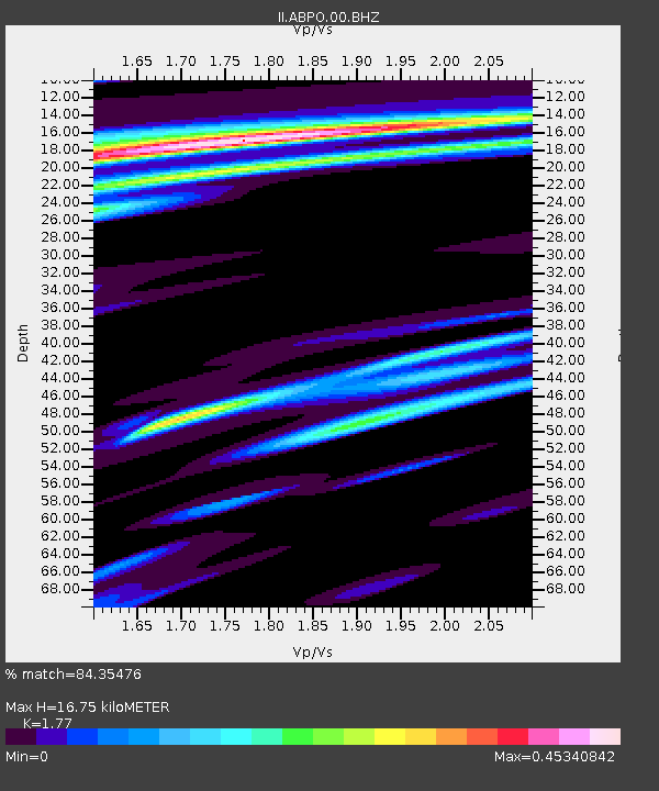
| Estimated Moho Depth: |
16.75 km |
| Estimated Crust Vp/Vs: |
1.77 |
| Assumed Crust Vp: |
6.642 km/s |
| Estimated Crust Vs: |
3.752 km/s |
| Estimated Crust Poisson's Ratio: |
0.27 |
|
| Radial Match: |
84.35476 % |
| Radial Bump: |
400 |
| Transverse Match: |
65.65643 % |
| Transverse Bump: |
400 |
| SOD ConfigId: |
23341671 |
| Insert Time: |
2021-01-25 22:48:55.697 +0000 |
| GWidth: |
2.5 |
| Max Bumps: |
400 |
| Tol: |
0.001 |
|
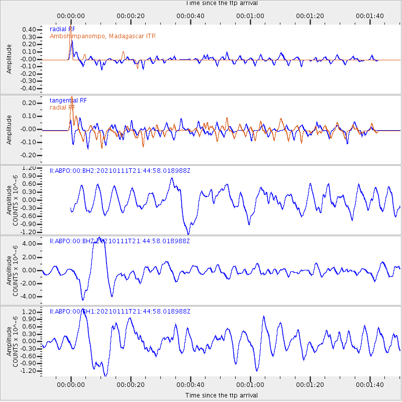
Signal To Noise
| Channel | StoN | STA | LTA |
| II:ABPO:00:BHZ:20210111T21:44:58.018988Z | 4.608927 | 2.1134638E-6 | 4.5855873E-7 |
| II:ABPO:00:BH1:20210111T21:44:58.018988Z | 2.2689106 | 7.3119475E-7 | 3.2226689E-7 |
| II:ABPO:00:BH2:20210111T21:44:58.018988Z | 1.3361349 | 4.3696085E-7 | 3.270335E-7 |
| Arrivals |
| Ps | 2.0 SECOND |
| PpPs | 6.8 SECOND |
| PsPs/PpSs | 8.8 SECOND |


