You are here: Home > Network List > IW - Intermountain West Stations List
> Station MFID Near Bowns Crk and Slater Flat Rd, Idaho, USA > Earthquake Result Viewer
MFID Near Bowns Crk and Slater Flat Rd, Idaho, USA - Earthquake Result Viewer
| Earthquake location: |
Russia-Mongolia Border Region |
| Earthquake latitude/longitude: |
51.2/100.4 |
| Earthquake time(UTC): |
2021/01/11 (011) 21:32:58 GMT |
| Earthquake Depth: |
10 km |
| Earthquake Magnitude: |
6.7 mww |
| Earthquake Catalog/Contributor: |
NEIC PDE/us |
|
| Network: |
IW Intermountain West |
| Station: |
MFID Near Bowns Crk and Slater Flat Rd, Idaho, USA |
| Lat/Lon: |
43.42 N/115.83 W |
| Elevation: |
1302 m |
|
| Distance: |
80.6 deg |
| Az: |
25.906 deg |
| Baz: |
337.858 deg |
| Ray Param: |
0.04816653 |
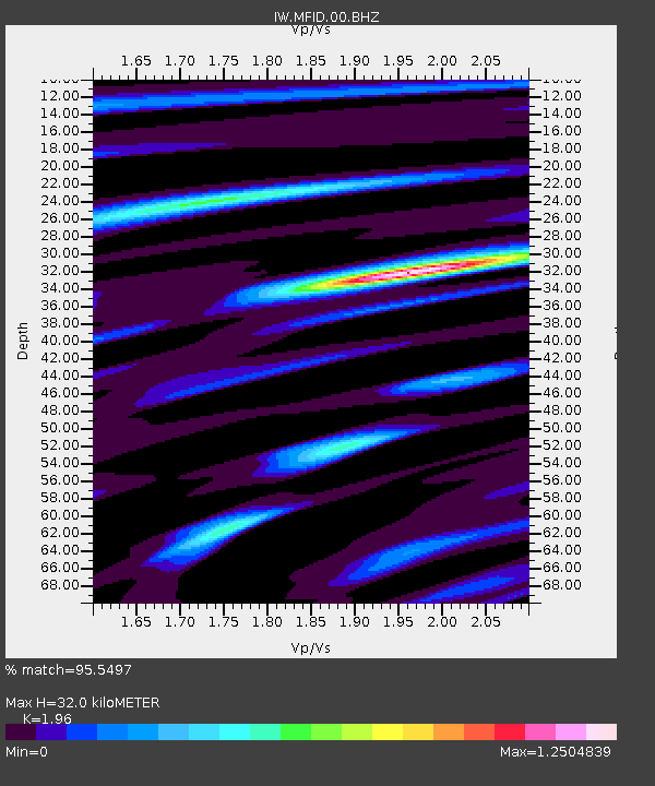
| Estimated Moho Depth: |
32.0 km |
| Estimated Crust Vp/Vs: |
1.96 |
| Assumed Crust Vp: |
6.291 km/s |
| Estimated Crust Vs: |
3.21 km/s |
| Estimated Crust Poisson's Ratio: |
0.32 |
|
| Radial Match: |
95.5497 % |
| Radial Bump: |
400 |
| Transverse Match: |
84.82021 % |
| Transverse Bump: |
400 |
| SOD ConfigId: |
23341671 |
| Insert Time: |
2021-01-25 22:50:01.335 +0000 |
| GWidth: |
2.5 |
| Max Bumps: |
400 |
| Tol: |
0.001 |
|

Signal To Noise
| Channel | StoN | STA | LTA |
| IW:MFID:00:BHZ:20210111T21:44:40.224005Z | 3.2181306 | 1.6179862E-6 | 5.027721E-7 |
| IW:MFID:00:BH1:20210111T21:44:40.224005Z | 2.255315 | 7.4851135E-7 | 3.318877E-7 |
| IW:MFID:00:BH2:20210111T21:44:40.224005Z | 0.97466004 | 3.1064693E-7 | 3.1872338E-7 |
| Arrivals |
| Ps | 5.0 SECOND |
| PpPs | 15 SECOND |
| PsPs/PpSs | 20 SECOND |


