You are here: Home > Network List > JP - Japan Meteorological Agency Seismic Network Stations List
> Station JGF Gifu Kurokawa > Earthquake Result Viewer
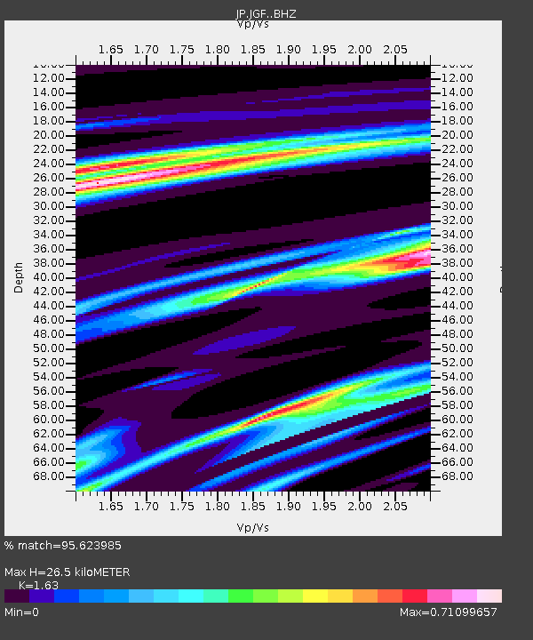
JGF Gifu Kurokawa - Earthquake Result Viewer
| Earthquake location: |
Russia-Mongolia Border Region |
| Earthquake latitude/longitude: |
51.2/100.4 |
| Earthquake time(UTC): |
2021/01/11 (011) 21:32:58 GMT |
| Earthquake Depth: |
10 km |
| Earthquake Magnitude: |
6.7 mww |
| Earthquake Catalog/Contributor: |
NEIC PDE/us |
|
| Network: |
JP Japan Meteorological Agency Seismic Network |
| Station: |
JGF Gifu Kurokawa |
| Lat/Lon: |
35.60 N/137.35 E |
| Elevation: |
580 m |
|
| Distance: |
30.6 deg |
| Az: |
106.217 deg |
| Baz: |
312.209 deg |
| Ray Param: |
0.079356275 |
| Estimated Moho Depth: |
26.5 km |
| Estimated Crust Vp/Vs: |
1.63 |
| Assumed Crust Vp: |
6.461 km/s |
| Estimated Crust Vs: |
3.964 km/s |
| Estimated Crust Poisson's Ratio: |
0.20 |
|
| Radial Match: |
95.623985 % |
| Radial Bump: |
251 |
| Transverse Match: |
69.09373 % |
| Transverse Bump: |
400 |
| SOD ConfigId: |
23341671 |
| Insert Time: |
2021-01-25 22:50:07.593 +0000 |
| GWidth: |
2.5 |
| Max Bumps: |
400 |
| Tol: |
0.001 |
|

Signal To Noise
| Channel | StoN | STA | LTA |
| JP:JGF: :BHZ:20210111T21:38:42.750006Z | 7.5371637 | 1.26794E-6 | 1.6822507E-7 |
| JP:JGF: :BHN:20210111T21:38:42.750006Z | 4.612389 | 6.5614034E-7 | 1.4225608E-7 |
| JP:JGF: :BHE:20210111T21:38:42.750006Z | 5.4887075 | 7.0010526E-7 | 1.2755376E-7 |
| Arrivals |
| Ps | 2.8 SECOND |
| PpPs | 9.9 SECOND |
| PsPs/PpSs | 13 SECOND |


