You are here: Home > Network List > MB - Montana Regional Seismic Network Stations List
> Station HLMT Hummingbird Lane > Earthquake Result Viewer
HLMT Hummingbird Lane - Earthquake Result Viewer
| Earthquake location: |
Russia-Mongolia Border Region |
| Earthquake latitude/longitude: |
51.2/100.4 |
| Earthquake time(UTC): |
2021/01/11 (011) 21:32:58 GMT |
| Earthquake Depth: |
10 km |
| Earthquake Magnitude: |
6.7 mww |
| Earthquake Catalog/Contributor: |
NEIC PDE/us |
|
| Network: |
MB Montana Regional Seismic Network |
| Station: |
HLMT Hummingbird Lane |
| Lat/Lon: |
45.90 N/112.56 W |
| Elevation: |
1843 m |
|
| Distance: |
79.1 deg |
| Az: |
22.779 deg |
| Baz: |
339.601 deg |
| Ray Param: |
0.049175434 |
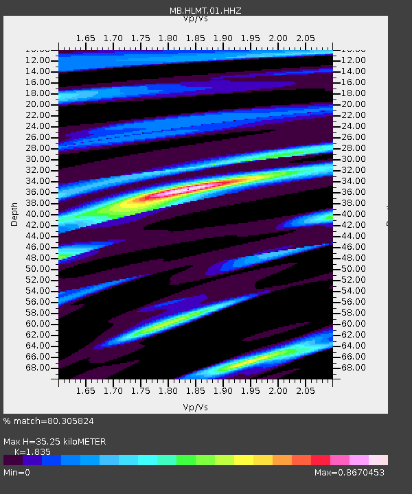
| Estimated Moho Depth: |
35.25 km |
| Estimated Crust Vp/Vs: |
1.84 |
| Assumed Crust Vp: |
6.577 km/s |
| Estimated Crust Vs: |
3.584 km/s |
| Estimated Crust Poisson's Ratio: |
0.29 |
|
| Radial Match: |
80.305824 % |
| Radial Bump: |
400 |
| Transverse Match: |
32.648186 % |
| Transverse Bump: |
400 |
| SOD ConfigId: |
23341671 |
| Insert Time: |
2021-01-25 22:50:49.800 +0000 |
| GWidth: |
2.5 |
| Max Bumps: |
400 |
| Tol: |
0.001 |
|

Signal To Noise
| Channel | StoN | STA | LTA |
| MB:HLMT:01:HHZ:20210111T21:44:32.270026Z | 5.548933 | 1.787667E-6 | 3.221641E-7 |
| MB:HLMT:01:HHN:20210111T21:44:32.270026Z | 1.4624937 | 9.278317E-7 | 6.3441763E-7 |
| MB:HLMT:01:HHE:20210111T21:44:32.270026Z | 0.81298304 | 1.6628561E-6 | 2.045376E-6 |
| Arrivals |
| Ps | 4.6 SECOND |
| PpPs | 15 SECOND |
| PsPs/PpSs | 19 SECOND |


