You are here: Home > Network List > NM - Cooperative New Madrid Seismic Network Stations List
> Station CGM3 Cape Girardeau, MO > Earthquake Result Viewer
CGM3 Cape Girardeau, MO - Earthquake Result Viewer
| Earthquake location: |
Russia-Mongolia Border Region |
| Earthquake latitude/longitude: |
51.2/100.4 |
| Earthquake time(UTC): |
2021/01/11 (011) 21:32:58 GMT |
| Earthquake Depth: |
10 km |
| Earthquake Magnitude: |
6.7 mww |
| Earthquake Catalog/Contributor: |
NEIC PDE/us |
|
| Network: |
NM Cooperative New Madrid Seismic Network |
| Station: |
CGM3 Cape Girardeau, MO |
| Lat/Lon: |
37.30 N/89.66 W |
| Elevation: |
148 m |
|
| Distance: |
91.4 deg |
| Az: |
8.038 deg |
| Baz: |
353.672 deg |
| Ray Param: |
0.041613217 |
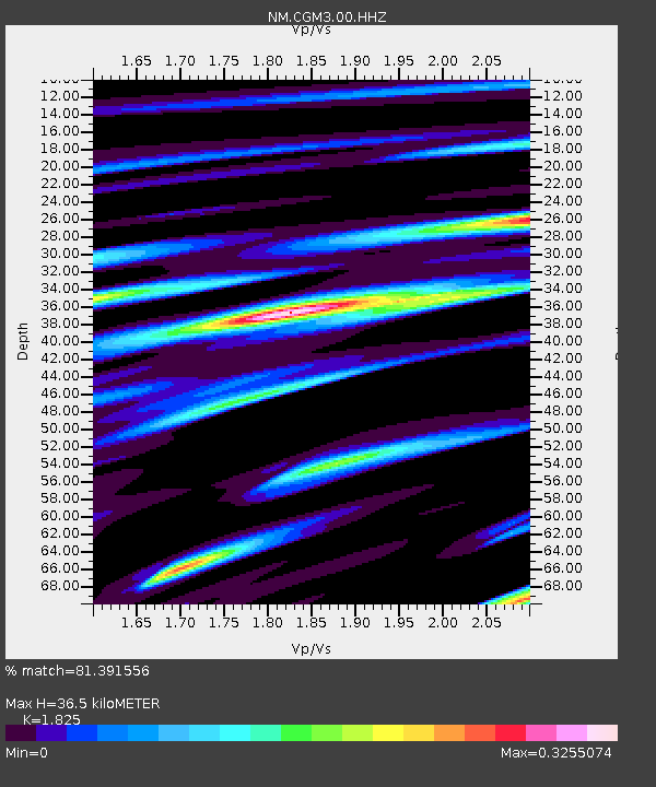
| Estimated Moho Depth: |
36.5 km |
| Estimated Crust Vp/Vs: |
1.83 |
| Assumed Crust Vp: |
6.444 km/s |
| Estimated Crust Vs: |
3.531 km/s |
| Estimated Crust Poisson's Ratio: |
0.29 |
|
| Radial Match: |
81.391556 % |
| Radial Bump: |
334 |
| Transverse Match: |
60.798706 % |
| Transverse Bump: |
400 |
| SOD ConfigId: |
23341671 |
| Insert Time: |
2021-01-25 22:53:57.442 +0000 |
| GWidth: |
2.5 |
| Max Bumps: |
400 |
| Tol: |
0.001 |
|

Signal To Noise
| Channel | StoN | STA | LTA |
| NM:CGM3:00:HHZ:20210111T21:45:33.409979Z | 3.2835753 | 8.3604067E-7 | 2.546129E-7 |
| NM:CGM3:00:HHN:20210111T21:45:33.409979Z | 1.298653 | 4.084914E-7 | 3.1455005E-7 |
| NM:CGM3:00:HHE:20210111T21:45:33.409979Z | 0.8070308 | 1.4080841E-7 | 1.7447712E-7 |
| Arrivals |
| Ps | 4.8 SECOND |
| PpPs | 16 SECOND |
| PsPs/PpSs | 20 SECOND |


