You are here: Home > Network List > NN - Western Great Basin/Eastern Sierra Nevada Stations List
> Station MCA06 Monte Cristo ASL 06 > Earthquake Result Viewer
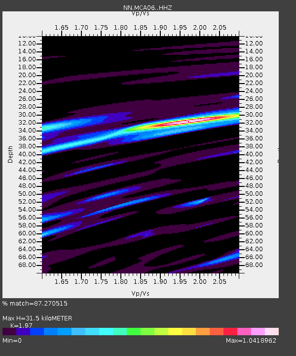
MCA06 Monte Cristo ASL 06 - Earthquake Result Viewer
| Earthquake location: |
Russia-Mongolia Border Region |
| Earthquake latitude/longitude: |
51.2/100.4 |
| Earthquake time(UTC): |
2021/01/11 (011) 21:32:58 GMT |
| Earthquake Depth: |
10 km |
| Earthquake Magnitude: |
6.7 mww |
| Earthquake Catalog/Contributor: |
NEIC PDE/us |
|
| Network: |
NN Western Great Basin/Eastern Sierra Nevada |
| Station: |
MCA06 Monte Cristo ASL 06 |
| Lat/Lon: |
38.01 N/117.88 W |
| Elevation: |
1462 m |
|
| Distance: |
85.0 deg |
| Az: |
29.45 deg |
| Baz: |
336.967 deg |
| Ray Param: |
0.045091264 |
| Estimated Moho Depth: |
31.5 km |
| Estimated Crust Vp/Vs: |
1.97 |
| Assumed Crust Vp: |
6.276 km/s |
| Estimated Crust Vs: |
3.186 km/s |
| Estimated Crust Poisson's Ratio: |
0.33 |
|
| Radial Match: |
87.270515 % |
| Radial Bump: |
354 |
| Transverse Match: |
73.84601 % |
| Transverse Bump: |
357 |
| SOD ConfigId: |
23341671 |
| Insert Time: |
2021-01-25 22:55:02.132 +0000 |
| GWidth: |
2.5 |
| Max Bumps: |
400 |
| Tol: |
0.001 |
|

Signal To Noise
| Channel | StoN | STA | LTA |
| NN:MCA06: :HHZ:20210111T21:45:02.89997Z | 3.5264883 | 1.2368729E-6 | 3.5073785E-7 |
| NN:MCA06: :HHN:20210111T21:45:02.89997Z | 1.1956037 | 5.6090744E-7 | 4.691416E-7 |
| NN:MCA06: :HHE:20210111T21:45:02.89997Z | 0.6946454 | 1.7471086E-7 | 2.5151087E-7 |
| Arrivals |
| Ps | 5.0 SECOND |
| PpPs | 15 SECOND |
| PsPs/PpSs | 20 SECOND |


