You are here: Home > Network List > WY - Yellowstone Wyoming Seismic Network Stations List
> Station YNR Norris Junction, YNP, WY, USA > Earthquake Result Viewer
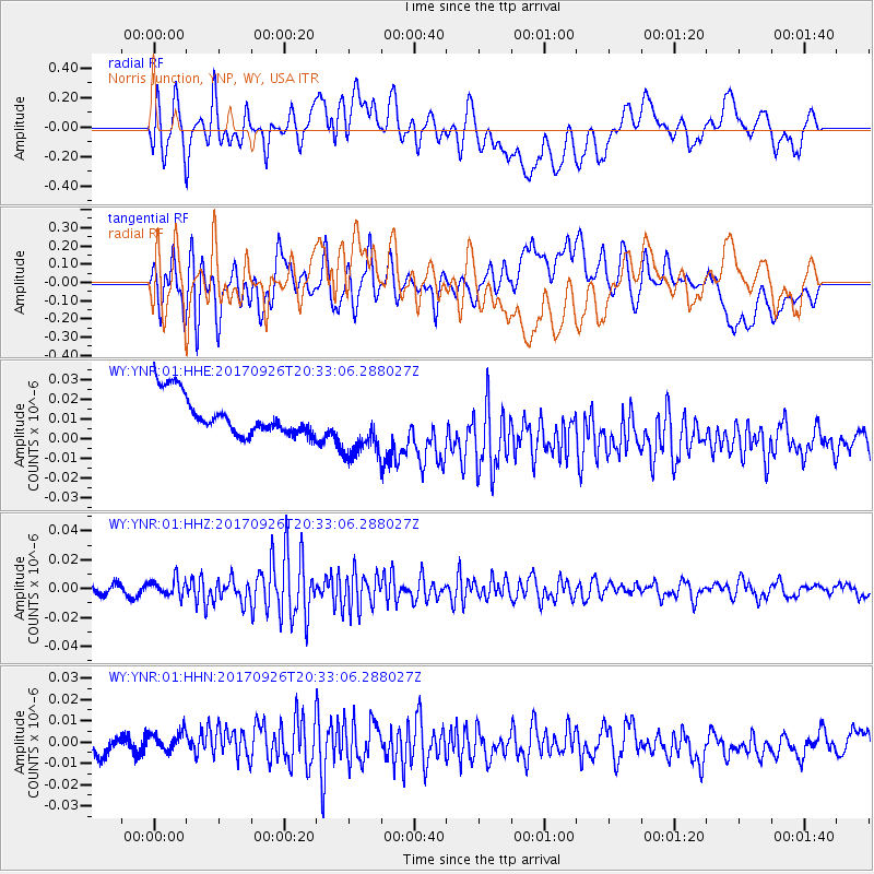
YNR Norris Junction, YNP, WY, USA - Earthquake Result Viewer
*The percent match for this event was below the threshold and hence no stack was calculated.
| Earthquake location: |
Near East Coast Of Honshu, Japan |
| Earthquake latitude/longitude: |
40.3/142.4 |
| Earthquake time(UTC): |
2017/09/26 (269) 20:22:11 GMT |
| Earthquake Depth: |
36 km |
| Earthquake Magnitude: |
5.8 Mww |
| Earthquake Catalog/Contributor: |
NEIC PDE/us |
|
| Network: |
WY Yellowstone Wyoming Seismic Network |
| Station: |
YNR Norris Junction, YNP, WY, USA |
| Lat/Lon: |
44.72 N/110.68 W |
| Elevation: |
2336 m |
|
| Distance: |
72.9 deg |
| Az: |
45.521 deg |
| Baz: |
310.079 deg |
| Ray Param: |
$rayparam |
*The percent match for this event was below the threshold and hence was not used in the summary stack. |
|
| Radial Match: |
40.35915 % |
| Radial Bump: |
400 |
| Transverse Match: |
35.473316 % |
| Transverse Bump: |
400 |
| SOD ConfigId: |
2364251 |
| Insert Time: |
2017-10-10 20:39:52.986 +0000 |
| GWidth: |
2.5 |
| Max Bumps: |
400 |
| Tol: |
0.001 |
|
Signal To Noise
| Channel | StoN | STA | LTA |
| WY:YNR:01:HHZ:20170926T20:33:06.288027Z | 2.4695768 | 6.051675E-9 | 2.4504905E-9 |
| WY:YNR:01:HHN:20170926T20:33:06.288027Z | 1.5375134 | 5.056923E-9 | 3.289027E-9 |
| WY:YNR:01:HHE:20170926T20:33:06.288027Z | 1.6579121 | 1.6233997E-8 | 9.791833E-9 |
| Arrivals |
| Ps | |
| PpPs | |
| PsPs/PpSs | |


