You are here: Home > Network List > PL - Polish Seismological Network Stations List
> Station BEL PLSN Station Belsk, Poland > Earthquake Result Viewer
BEL PLSN Station Belsk, Poland - Earthquake Result Viewer
| Earthquake location: |
Russia-Mongolia Border Region |
| Earthquake latitude/longitude: |
51.2/100.4 |
| Earthquake time(UTC): |
2021/01/11 (011) 21:32:58 GMT |
| Earthquake Depth: |
10 km |
| Earthquake Magnitude: |
6.7 mww |
| Earthquake Catalog/Contributor: |
NEIC PDE/us |
|
| Network: |
PL Polish Seismological Network |
| Station: |
BEL PLSN Station Belsk, Poland |
| Lat/Lon: |
51.84 N/20.79 E |
| Elevation: |
180 m |
|
| Distance: |
47.2 deg |
| Az: |
303.647 deg |
| Baz: |
57.501 deg |
| Ray Param: |
0.07018522 |
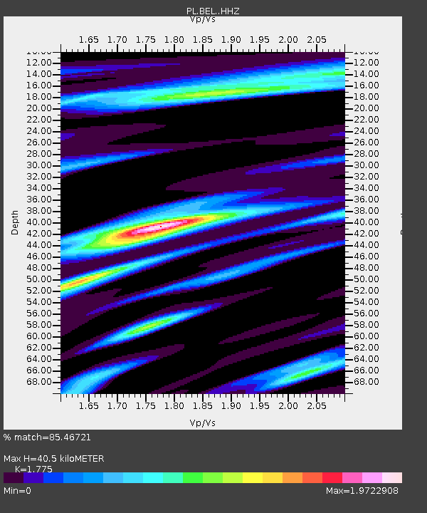
| Estimated Moho Depth: |
40.5 km |
| Estimated Crust Vp/Vs: |
1.77 |
| Assumed Crust Vp: |
6.426 km/s |
| Estimated Crust Vs: |
3.62 km/s |
| Estimated Crust Poisson's Ratio: |
0.27 |
|
| Radial Match: |
85.46721 % |
| Radial Bump: |
400 |
| Transverse Match: |
67.84985 % |
| Transverse Bump: |
400 |
| SOD ConfigId: |
23341671 |
| Insert Time: |
2021-01-25 22:58:24.474 +0000 |
| GWidth: |
2.5 |
| Max Bumps: |
400 |
| Tol: |
0.001 |
|

Signal To Noise
| Channel | StoN | STA | LTA |
| PL:BEL: :HHZ:20210111T21:41:00.466986Z | 3.4210968 | 8.042379E-6 | 2.350819E-6 |
| PL:BEL: :HHN:20210111T21:41:00.466986Z | 0.9594132 | 3.8170665E-6 | 3.9785427E-6 |
| PL:BEL: :HHE:20210111T21:41:00.466986Z | 0.9853874 | 3.903453E-6 | 3.9613387E-6 |
| Arrivals |
| Ps | 5.2 SECOND |
| PpPs | 16 SECOND |
| PsPs/PpSs | 22 SECOND |


