You are here: Home > Network List > RM - Regional Integrated Multi Hazard Early Warning System Stations List
> Station SZP Santa Ilocos Sur > Earthquake Result Viewer
SZP Santa Ilocos Sur - Earthquake Result Viewer
| Earthquake location: |
Russia-Mongolia Border Region |
| Earthquake latitude/longitude: |
51.2/100.4 |
| Earthquake time(UTC): |
2021/01/11 (011) 21:32:58 GMT |
| Earthquake Depth: |
10 km |
| Earthquake Magnitude: |
6.7 mww |
| Earthquake Catalog/Contributor: |
NEIC PDE/us |
|
| Network: |
RM Regional Integrated Multi Hazard Early Warning System |
| Station: |
SZP Santa Ilocos Sur |
| Lat/Lon: |
17.55 N/120.46 E |
| Elevation: |
100 m |
|
| Distance: |
37.2 deg |
| Az: |
147.302 deg |
| Baz: |
339.148 deg |
| Ray Param: |
0.07628657 |
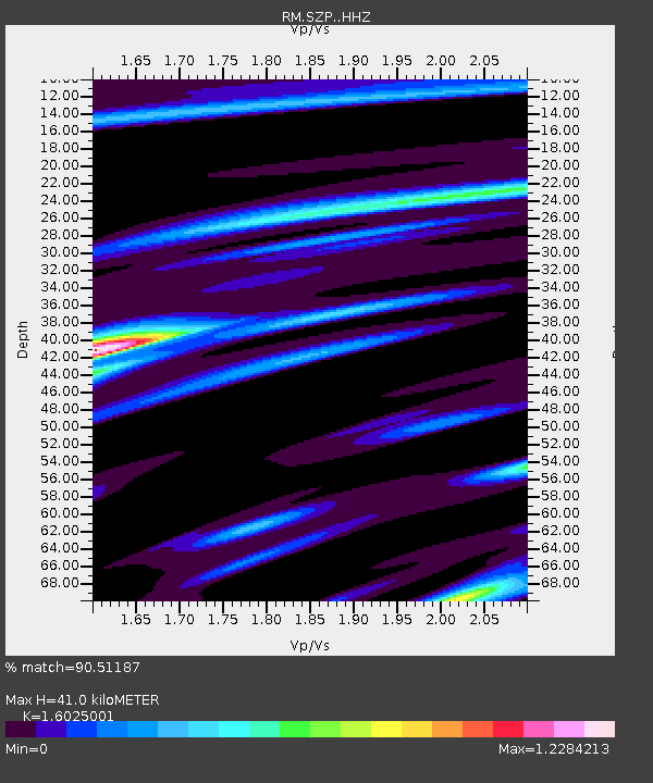
| Estimated Moho Depth: |
41.0 km |
| Estimated Crust Vp/Vs: |
1.60 |
| Assumed Crust Vp: |
6.468 km/s |
| Estimated Crust Vs: |
4.036 km/s |
| Estimated Crust Poisson's Ratio: |
0.18 |
|
| Radial Match: |
90.51187 % |
| Radial Bump: |
283 |
| Transverse Match: |
80.42707 % |
| Transverse Bump: |
390 |
| SOD ConfigId: |
23341671 |
| Insert Time: |
2021-01-25 22:59:18.431 +0000 |
| GWidth: |
2.5 |
| Max Bumps: |
400 |
| Tol: |
0.001 |
|

Signal To Noise
| Channel | StoN | STA | LTA |
| RM:SZP: :HHZ:20210111T21:39:39.388007Z | 4.21093 | 3.237061E-6 | 7.687283E-7 |
| RM:SZP: :HHN:20210111T21:39:39.388007Z | 3.1253967 | 2.4661158E-6 | 7.8905686E-7 |
| RM:SZP: :HHE:20210111T21:39:39.388007Z | 0.8376219 | 5.7240385E-7 | 6.833678E-7 |
| Arrivals |
| Ps | 4.2 SECOND |
| PpPs | 15 SECOND |
| PsPs/PpSs | 19 SECOND |


