You are here: Home > Network List > TA - USArray Transportable Network (new EarthScope stations) Stations List
> Station J30M Hart River, Yukon, CAN > Earthquake Result Viewer
J30M Hart River, Yukon, CAN - Earthquake Result Viewer
| Earthquake location: |
Russia-Mongolia Border Region |
| Earthquake latitude/longitude: |
51.2/100.4 |
| Earthquake time(UTC): |
2021/01/11 (011) 21:32:58 GMT |
| Earthquake Depth: |
10 km |
| Earthquake Magnitude: |
6.7 mww |
| Earthquake Catalog/Contributor: |
NEIC PDE/us |
|
| Network: |
TA USArray Transportable Network (new EarthScope stations) |
| Station: |
J30M Hart River, Yukon, CAN |
| Lat/Lon: |
64.58 N/136.33 W |
| Elevation: |
1419 m |
|
| Distance: |
56.4 deg |
| Az: |
25.678 deg |
| Baz: |
320.877 deg |
| Ray Param: |
0.06414503 |
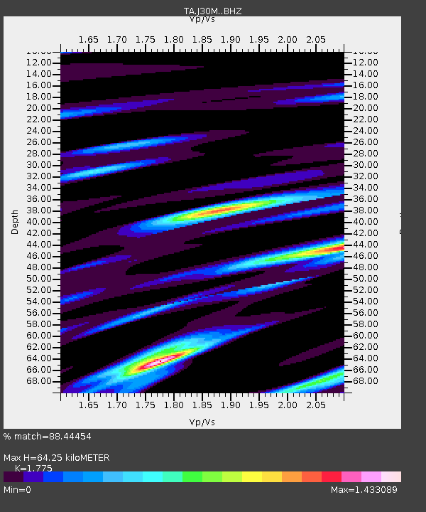
| Estimated Moho Depth: |
64.25 km |
| Estimated Crust Vp/Vs: |
1.77 |
| Assumed Crust Vp: |
6.566 km/s |
| Estimated Crust Vs: |
3.699 km/s |
| Estimated Crust Poisson's Ratio: |
0.27 |
|
| Radial Match: |
88.44454 % |
| Radial Bump: |
400 |
| Transverse Match: |
77.36364 % |
| Transverse Bump: |
400 |
| SOD ConfigId: |
23341671 |
| Insert Time: |
2021-01-25 23:01:18.893 +0000 |
| GWidth: |
2.5 |
| Max Bumps: |
400 |
| Tol: |
0.001 |
|

Signal To Noise
| Channel | StoN | STA | LTA |
| TA:J30M: :BHZ:20210111T21:42:09.64997Z | 5.6732535 | 1.5659587E-6 | 2.760248E-7 |
| TA:J30M: :BHN:20210111T21:42:09.64997Z | 4.5637093 | 1.0734841E-6 | 2.3522183E-7 |
| TA:J30M: :BHE:20210111T21:42:09.64997Z | 1.780343 | 5.5333E-7 | 3.1079963E-7 |
| Arrivals |
| Ps | 8.0 SECOND |
| PpPs | 26 SECOND |
| PsPs/PpSs | 34 SECOND |


