You are here: Home > Network List > TA - USArray Transportable Network (new EarthScope stations) Stations List
> Station O28M Mount Upton, YT, CAN > Earthquake Result Viewer
O28M Mount Upton, YT, CAN - Earthquake Result Viewer
| Earthquake location: |
Russia-Mongolia Border Region |
| Earthquake latitude/longitude: |
51.2/100.4 |
| Earthquake time(UTC): |
2021/01/11 (011) 21:32:58 GMT |
| Earthquake Depth: |
10 km |
| Earthquake Magnitude: |
6.7 mww |
| Earthquake Catalog/Contributor: |
NEIC PDE/us |
|
| Network: |
TA USArray Transportable Network (new EarthScope stations) |
| Station: |
O28M Mount Upton, YT, CAN |
| Lat/Lon: |
60.77 N/140.19 W |
| Elevation: |
2622 m |
|
| Distance: |
58.2 deg |
| Az: |
30.198 deg |
| Baz: |
319.891 deg |
| Ray Param: |
0.06296942 |
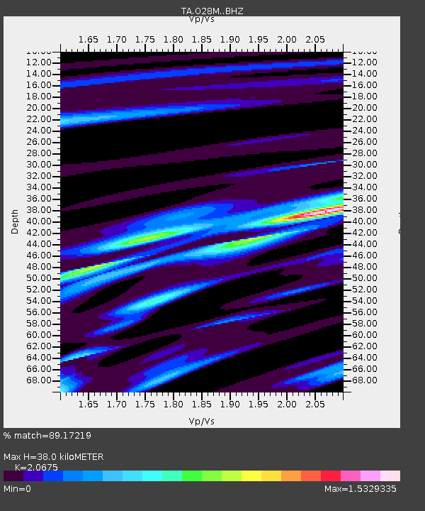
| Estimated Moho Depth: |
38.0 km |
| Estimated Crust Vp/Vs: |
2.07 |
| Assumed Crust Vp: |
6.566 km/s |
| Estimated Crust Vs: |
3.176 km/s |
| Estimated Crust Poisson's Ratio: |
0.35 |
|
| Radial Match: |
89.17219 % |
| Radial Bump: |
392 |
| Transverse Match: |
83.39763 % |
| Transverse Bump: |
400 |
| SOD ConfigId: |
23341671 |
| Insert Time: |
2021-01-25 23:01:42.919 +0000 |
| GWidth: |
2.5 |
| Max Bumps: |
400 |
| Tol: |
0.001 |
|

Signal To Noise
| Channel | StoN | STA | LTA |
| TA:O28M: :BHZ:20210111T21:42:22.375006Z | 2.5462592 | 1.2274486E-6 | 4.820596E-7 |
| TA:O28M: :BHN:20210111T21:42:22.375006Z | 1.1409636 | 6.50656E-7 | 5.7026887E-7 |
| TA:O28M: :BHE:20210111T21:42:22.375006Z | 0.563893 | 4.253985E-7 | 7.543957E-7 |
| Arrivals |
| Ps | 6.5 SECOND |
| PpPs | 17 SECOND |
| PsPs/PpSs | 23 SECOND |


