You are here: Home > Network List > TX - Texas Seismological Network Stations List
> Station FW06 Azle > Earthquake Result Viewer
FW06 Azle - Earthquake Result Viewer
| Earthquake location: |
Russia-Mongolia Border Region |
| Earthquake latitude/longitude: |
51.2/100.4 |
| Earthquake time(UTC): |
2021/01/11 (011) 21:32:58 GMT |
| Earthquake Depth: |
10 km |
| Earthquake Magnitude: |
6.7 mww |
| Earthquake Catalog/Contributor: |
NEIC PDE/us |
|
| Network: |
TX Texas Seismological Network |
| Station: |
FW06 Azle |
| Lat/Lon: |
32.97 N/97.56 W |
| Elevation: |
233 m |
|
| Distance: |
94.7 deg |
| Az: |
15.102 deg |
| Baz: |
348.765 deg |
| Ray Param: |
0.040990304 |
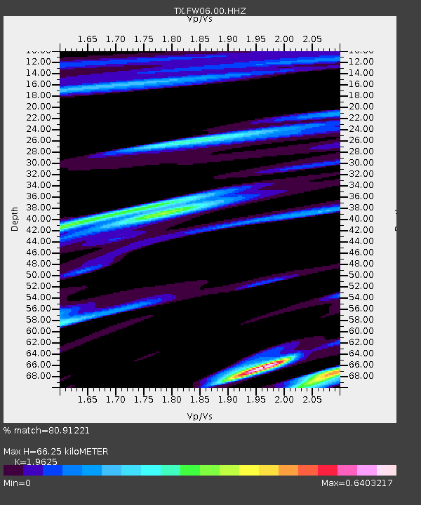
| Estimated Moho Depth: |
66.25 km |
| Estimated Crust Vp/Vs: |
1.96 |
| Assumed Crust Vp: |
6.38 km/s |
| Estimated Crust Vs: |
3.251 km/s |
| Estimated Crust Poisson's Ratio: |
0.32 |
|
| Radial Match: |
80.91221 % |
| Radial Bump: |
395 |
| Transverse Match: |
51.836037 % |
| Transverse Bump: |
395 |
| SOD ConfigId: |
23341671 |
| Insert Time: |
2021-01-25 23:02:24.060 +0000 |
| GWidth: |
2.5 |
| Max Bumps: |
400 |
| Tol: |
0.001 |
|

Signal To Noise
| Channel | StoN | STA | LTA |
| TX:FW06:00:HHZ:20210111T21:45:48.419989Z | 2.0702033 | 5.644514E-7 | 2.7265506E-7 |
| TX:FW06:00:HH1:20210111T21:45:48.419989Z | 1.6887778 | 3.913459E-7 | 2.3173321E-7 |
| TX:FW06:00:HH2:20210111T21:45:48.419989Z | 0.8450027 | 2.8726004E-7 | 3.399516E-7 |
| Arrivals |
| Ps | 10 SECOND |
| PpPs | 30 SECOND |
| PsPs/PpSs | 40 SECOND |


