You are here: Home > Network List > US - United States National Seismic Network Stations List
> Station AMTX Amarillo, Texas, USA > Earthquake Result Viewer
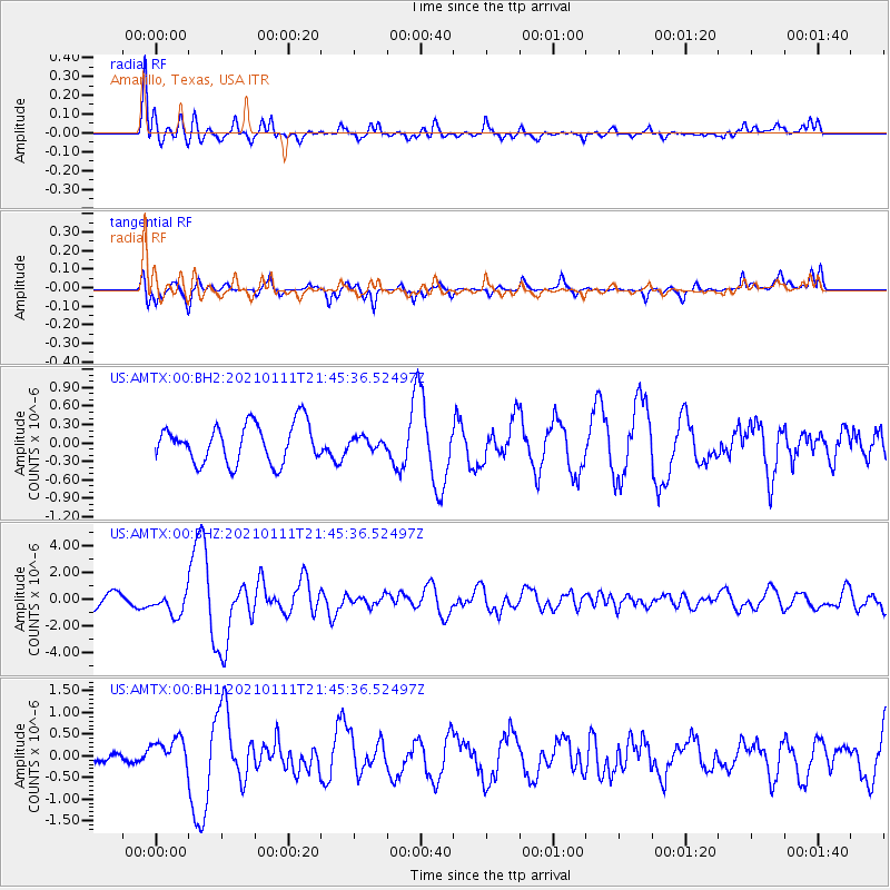
AMTX Amarillo, Texas, USA - Earthquake Result Viewer
*The percent match for this event was below the threshold and hence no stack was calculated.
| Earthquake location: |
Russia-Mongolia Border Region |
| Earthquake latitude/longitude: |
51.2/100.4 |
| Earthquake time(UTC): |
2021/01/11 (011) 21:32:58 GMT |
| Earthquake Depth: |
10 km |
| Earthquake Magnitude: |
6.7 mww |
| Earthquake Catalog/Contributor: |
NEIC PDE/us |
|
| Network: |
US United States National Seismic Network |
| Station: |
AMTX Amarillo, Texas, USA |
| Lat/Lon: |
34.53 N/101.41 W |
| Elevation: |
1010 m |
|
| Distance: |
92.5 deg |
| Az: |
17.909 deg |
| Baz: |
346.46 deg |
| Ray Param: |
$rayparam |
*The percent match for this event was below the threshold and hence was not used in the summary stack. |
|
| Radial Match: |
85.54629 % |
| Radial Bump: |
400 |
| Transverse Match: |
70.46024 % |
| Transverse Bump: |
400 |
| SOD ConfigId: |
23341671 |
| Insert Time: |
2021-01-25 23:03:49.473 +0000 |
| GWidth: |
2.5 |
| Max Bumps: |
400 |
| Tol: |
0.001 |
|
Signal To Noise
| Channel | StoN | STA | LTA |
| US:AMTX:00:BHZ:20210111T21:45:36.52497Z | 2.3164382 | 8.279736E-7 | 3.5743392E-7 |
| US:AMTX:00:BH1:20210111T21:45:36.52497Z | 1.9362367 | 3.4809403E-7 | 1.7977865E-7 |
| US:AMTX:00:BH2:20210111T21:45:36.52497Z | 0.5882163 | 1.8287224E-7 | 3.1089286E-7 |
| Arrivals |
| Ps | |
| PpPs | |
| PsPs/PpSs | |


