You are here: Home > Network List > US - United States National Seismic Network Stations List
> Station DGMT Dagmar, Montana, USA > Earthquake Result Viewer
DGMT Dagmar, Montana, USA - Earthquake Result Viewer
| Earthquake location: |
Russia-Mongolia Border Region |
| Earthquake latitude/longitude: |
51.2/100.4 |
| Earthquake time(UTC): |
2021/01/11 (011) 21:32:58 GMT |
| Earthquake Depth: |
10 km |
| Earthquake Magnitude: |
6.7 mww |
| Earthquake Catalog/Contributor: |
NEIC PDE/us |
|
| Network: |
US United States National Seismic Network |
| Station: |
DGMT Dagmar, Montana, USA |
| Lat/Lon: |
48.47 N/104.20 W |
| Elevation: |
0.0 m |
|
| Distance: |
78.5 deg |
| Az: |
16.446 deg |
| Baz: |
344.489 deg |
| Ray Param: |
0.049636755 |
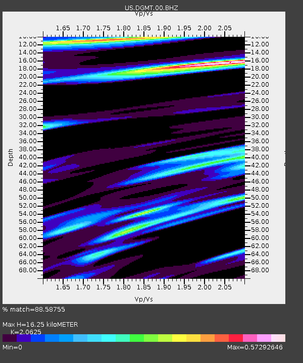
| Estimated Moho Depth: |
16.25 km |
| Estimated Crust Vp/Vs: |
2.06 |
| Assumed Crust Vp: |
6.438 km/s |
| Estimated Crust Vs: |
3.121 km/s |
| Estimated Crust Poisson's Ratio: |
0.35 |
|
| Radial Match: |
88.58755 % |
| Radial Bump: |
360 |
| Transverse Match: |
77.340744 % |
| Transverse Bump: |
383 |
| SOD ConfigId: |
23341671 |
| Insert Time: |
2021-01-25 23:04:01.219 +0000 |
| GWidth: |
2.5 |
| Max Bumps: |
400 |
| Tol: |
0.001 |
|

Signal To Noise
| Channel | StoN | STA | LTA |
| US:DGMT:00:BHZ:20210111T21:44:28.549018Z | 4.642439 | 1.5038266E-6 | 3.2393032E-7 |
| US:DGMT:00:BH1:20210111T21:44:28.549018Z | 1.2574189 | 9.667339E-7 | 7.68824E-7 |
| US:DGMT:00:BH2:20210111T21:44:28.549018Z | 1.1775095 | 1.1957907E-6 | 1.0155253E-6 |
| Arrivals |
| Ps | 2.8 SECOND |
| PpPs | 7.5 SECOND |
| PsPs/PpSs | 10 SECOND |


