You are here: Home > Network List > GE - GEOFON Stations List
> Station DSB GEOFON Station Dublin, Ireland > Earthquake Result Viewer
DSB GEOFON Station Dublin, Ireland - Earthquake Result Viewer
| Earthquake location: |
East Of Kuril Islands |
| Earthquake latitude/longitude: |
44.7/150.2 |
| Earthquake time(UTC): |
1994/08/18 (230) 04:42:59 GMT |
| Earthquake Depth: |
33 km |
| Earthquake Magnitude: |
6.1 MB, 6.5 MS, 6.6 UNKNOWN, 6.5 MW |
| Earthquake Catalog/Contributor: |
WHDF/NEIC |
|
| Network: |
GE GEOFON |
| Station: |
DSB GEOFON Station Dublin, Ireland |
| Lat/Lon: |
53.25 N/6.38 W |
| Elevation: |
236 m |
|
| Distance: |
80.4 deg |
| Az: |
345.963 deg |
| Baz: |
16.736 deg |
| Ray Param: |
0.04825316 |
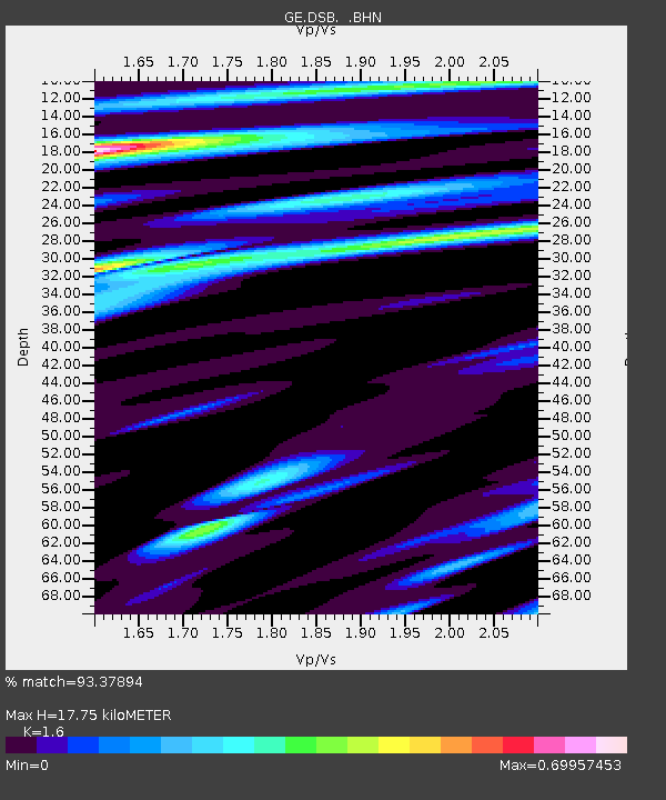
| Estimated Moho Depth: |
17.75 km |
| Estimated Crust Vp/Vs: |
1.60 |
| Assumed Crust Vp: |
6.276 km/s |
| Estimated Crust Vs: |
3.922 km/s |
| Estimated Crust Poisson's Ratio: |
0.18 |
|
| Radial Match: |
93.37894 % |
| Radial Bump: |
362 |
| Transverse Match: |
85.13532 % |
| Transverse Bump: |
400 |
| SOD ConfigId: |
17000 |
| Insert Time: |
2010-03-09 04:47:07.448 +0000 |
| GWidth: |
2.5 |
| Max Bumps: |
400 |
| Tol: |
0.001 |
|

Signal To Noise
| Channel | StoN | STA | LTA |
| GE:DSB: :BHN:19940818T04:54:36.706018Z | 4.36042 | 9.756901E-7 | 2.2376058E-7 |
| GE:DSB: :BHE:19940818T04:54:36.706018Z | 2.435784 | 4.58214E-7 | 1.8811765E-7 |
| GE:DSB: :BHZ:19940818T04:54:36.706018Z | 10.959108 | 2.7896651E-6 | 2.545522E-7 |
| Arrivals |
| Ps | 1.7 SECOND |
| PpPs | 7.1 SECOND |
| PsPs/PpSs | 8.9 SECOND |


