You are here: Home > Network List > TA - USArray Transportable Network (new EarthScope stations) Stations List
> Station H31M Peel River, Yukon, CAN > Earthquake Result Viewer
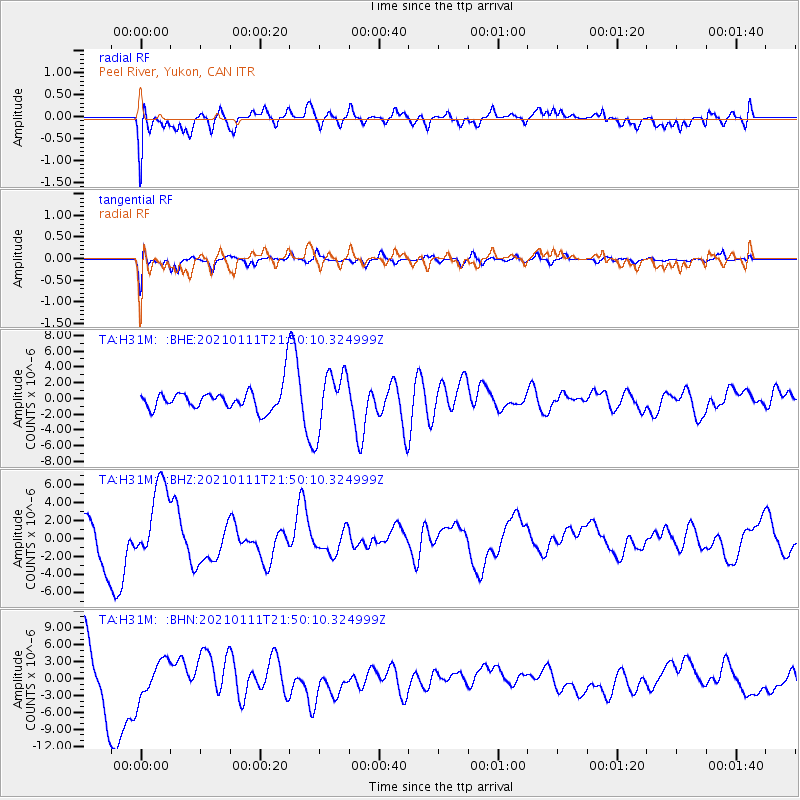
H31M Peel River, Yukon, CAN - Earthquake Result Viewer
*The percent match for this event was below the threshold and hence no stack was calculated.
| Earthquake location: |
Russia-Mongolia Border Region |
| Earthquake latitude/longitude: |
51.5/100.5 |
| Earthquake time(UTC): |
2021/01/11 (011) 21:41:04 GMT |
| Earthquake Depth: |
10 km |
| Earthquake Magnitude: |
5.8 mb |
| Earthquake Catalog/Contributor: |
NEIC PDE/us |
|
| Network: |
TA USArray Transportable Network (new EarthScope stations) |
| Station: |
H31M Peel River, Yukon, CAN |
| Lat/Lon: |
65.81 N/134.34 W |
| Elevation: |
642 m |
|
| Distance: |
55.8 deg |
| Az: |
24.058 deg |
| Baz: |
321.794 deg |
| Ray Param: |
$rayparam |
*The percent match for this event was below the threshold and hence was not used in the summary stack. |
|
| Radial Match: |
51.531925 % |
| Radial Bump: |
400 |
| Transverse Match: |
42.503685 % |
| Transverse Bump: |
400 |
| SOD ConfigId: |
23341671 |
| Insert Time: |
2021-01-25 23:25:14.284 +0000 |
| GWidth: |
2.5 |
| Max Bumps: |
400 |
| Tol: |
0.001 |
|
Signal To Noise
| Channel | StoN | STA | LTA |
| TA:H31M: :BHZ:20210111T21:50:10.324999Z | 2.373839 | 4.3946648E-6 | 1.8512903E-6 |
| TA:H31M: :BHN:20210111T21:50:10.324999Z | 0.8051979 | 3.3457052E-6 | 4.155134E-6 |
| TA:H31M: :BHE:20210111T21:50:10.324999Z | 2.4889193 | 3.7103143E-6 | 1.4907331E-6 |
| Arrivals |
| Ps | |
| PpPs | |
| PsPs/PpSs | |


