You are here: Home > Network List > TA - USArray Transportable Network (new EarthScope stations) Stations List
> Station I30M Mount Dempster, Yukon, CAN > Earthquake Result Viewer
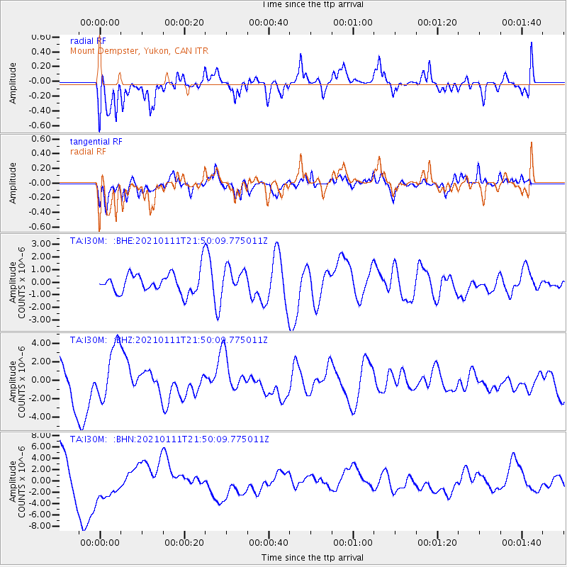
I30M Mount Dempster, Yukon, CAN - Earthquake Result Viewer
*The percent match for this event was below the threshold and hence no stack was calculated.
| Earthquake location: |
Russia-Mongolia Border Region |
| Earthquake latitude/longitude: |
51.5/100.5 |
| Earthquake time(UTC): |
2021/01/11 (011) 21:41:04 GMT |
| Earthquake Depth: |
10 km |
| Earthquake Magnitude: |
5.8 mb |
| Earthquake Catalog/Contributor: |
NEIC PDE/us |
|
| Network: |
TA USArray Transportable Network (new EarthScope stations) |
| Station: |
I30M Mount Dempster, Yukon, CAN |
| Lat/Lon: |
65.22 N/136.38 W |
| Elevation: |
1399 m |
|
| Distance: |
55.7 deg |
| Az: |
25.302 deg |
| Baz: |
320.645 deg |
| Ray Param: |
$rayparam |
*The percent match for this event was below the threshold and hence was not used in the summary stack. |
|
| Radial Match: |
47.23139 % |
| Radial Bump: |
400 |
| Transverse Match: |
54.848766 % |
| Transverse Bump: |
400 |
| SOD ConfigId: |
23341671 |
| Insert Time: |
2021-01-25 23:25:19.578 +0000 |
| GWidth: |
2.5 |
| Max Bumps: |
400 |
| Tol: |
0.001 |
|
Signal To Noise
| Channel | StoN | STA | LTA |
| TA:I30M: :BHZ:20210111T21:50:09.775011Z | 2.2429569 | 2.9763564E-6 | 1.3269788E-6 |
| TA:I30M: :BHN:20210111T21:50:09.775011Z | 1.1111219 | 3.1411166E-6 | 2.8269774E-6 |
| TA:I30M: :BHE:20210111T21:50:09.775011Z | 1.1381252 | 9.500635E-7 | 8.347619E-7 |
| Arrivals |
| Ps | |
| PpPs | |
| PsPs/PpSs | |


