You are here: Home > Network List > TA - USArray Transportable Network (new EarthScope stations) Stations List
> Station I17K Unalakleet, AK, USA > Earthquake Result Viewer
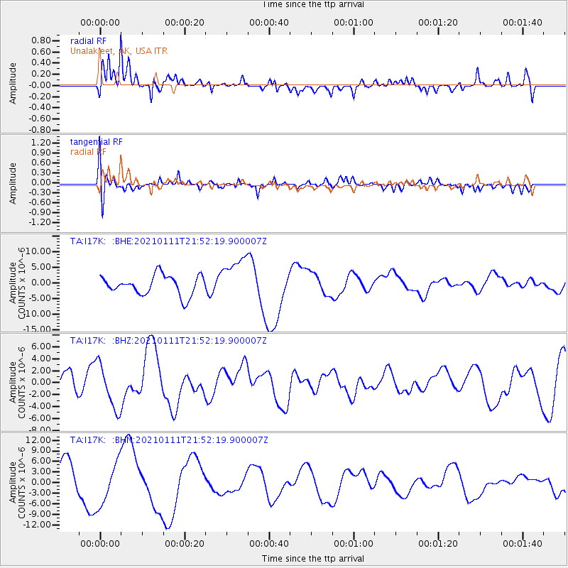
I17K Unalakleet, AK, USA - Earthquake Result Viewer
*The percent match for this event was below the threshold and hence no stack was calculated.
| Earthquake location: |
Russia-Mongolia Border Region |
| Earthquake latitude/longitude: |
51.4/100.5 |
| Earthquake time(UTC): |
2021/01/11 (011) 21:44:04 GMT |
| Earthquake Depth: |
10 km |
| Earthquake Magnitude: |
5.7 mb |
| Earthquake Catalog/Contributor: |
NEIC PDE/us |
|
| Network: |
TA USArray Transportable Network (new EarthScope stations) |
| Station: |
I17K Unalakleet, AK, USA |
| Lat/Lon: |
63.89 N/160.70 W |
| Elevation: |
105 m |
|
| Distance: |
49.0 deg |
| Az: |
35.437 deg |
| Baz: |
304.853 deg |
| Ray Param: |
$rayparam |
*The percent match for this event was below the threshold and hence was not used in the summary stack. |
|
| Radial Match: |
59.735847 % |
| Radial Bump: |
400 |
| Transverse Match: |
44.215458 % |
| Transverse Bump: |
388 |
| SOD ConfigId: |
23341671 |
| Insert Time: |
2021-01-25 23:48:15.546 +0000 |
| GWidth: |
2.5 |
| Max Bumps: |
400 |
| Tol: |
0.001 |
|
Signal To Noise
| Channel | StoN | STA | LTA |
| TA:I17K: :BHZ:20210111T21:52:19.900007Z | 1.7610745 | 3.8030746E-6 | 2.1595195E-6 |
| TA:I17K: :BHN:20210111T21:52:19.900007Z | 1.659104 | 6.0795805E-6 | 3.6643758E-6 |
| TA:I17K: :BHE:20210111T21:52:19.900007Z | 2.2693987 | 7.072624E-6 | 3.1165189E-6 |
| Arrivals |
| Ps | |
| PpPs | |
| PsPs/PpSs | |


