You are here: Home > Network List > AK - Alaska Regional Network Stations List
> Station CUT Chulitna, AK, USA > Earthquake Result Viewer
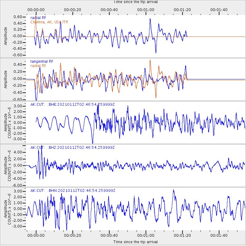
CUT Chulitna, AK, USA - Earthquake Result Viewer
*The percent match for this event was below the threshold and hence no stack was calculated.
| Earthquake location: |
Eastern Sea Of Japan |
| Earthquake latitude/longitude: |
43.7/140.0 |
| Earthquake time(UTC): |
2021/01/12 (012) 02:39:42 GMT |
| Earthquake Depth: |
211 km |
| Earthquake Magnitude: |
5.9 mww |
| Earthquake Catalog/Contributor: |
NEIC PDE/us |
|
| Network: |
AK Alaska Regional Network |
| Station: |
CUT Chulitna, AK, USA |
| Lat/Lon: |
62.41 N/150.26 W |
| Elevation: |
574 m |
|
| Distance: |
43.4 deg |
| Az: |
39.454 deg |
| Baz: |
278.227 deg |
| Ray Param: |
$rayparam |
*The percent match for this event was below the threshold and hence was not used in the summary stack. |
|
| Radial Match: |
55.55169 % |
| Radial Bump: |
400 |
| Transverse Match: |
42.86021 % |
| Transverse Bump: |
382 |
| SOD ConfigId: |
23341671 |
| Insert Time: |
2021-01-26 03:41:47.272 +0000 |
| GWidth: |
2.5 |
| Max Bumps: |
400 |
| Tol: |
0.001 |
|
Signal To Noise
| Channel | StoN | STA | LTA |
| AK:CUT: :BHZ:20210112T02:46:54.259999Z | 6.9515777 | 2.312586E-6 | 3.3267068E-7 |
| AK:CUT: :BHN:20210112T02:46:54.259999Z | 1.4254496 | 1.1521487E-6 | 8.0827033E-7 |
| AK:CUT: :BHE:20210112T02:46:54.259999Z | 2.1058865 | 1.8152781E-6 | 8.620019E-7 |
| Arrivals |
| Ps | |
| PpPs | |
| PsPs/PpSs | |


