You are here: Home > Network List > CI - Caltech Regional Seismic Network Stations List
> Station SWS Sam W. Stewart, Westmorland, CA, USA > Earthquake Result Viewer
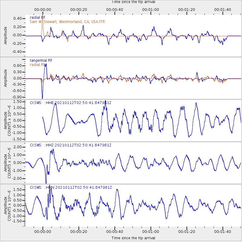
SWS Sam W. Stewart, Westmorland, CA, USA - Earthquake Result Viewer
*The percent match for this event was below the threshold and hence no stack was calculated.
| Earthquake location: |
Eastern Sea Of Japan |
| Earthquake latitude/longitude: |
43.7/140.0 |
| Earthquake time(UTC): |
2021/01/12 (012) 02:39:42 GMT |
| Earthquake Depth: |
211 km |
| Earthquake Magnitude: |
5.9 mww |
| Earthquake Catalog/Contributor: |
NEIC PDE/us |
|
| Network: |
CI Caltech Regional Seismic Network |
| Station: |
SWS Sam W. Stewart, Westmorland, CA, USA |
| Lat/Lon: |
32.94 N/115.80 W |
| Elevation: |
140 m |
|
| Distance: |
77.1 deg |
| Az: |
56.742 deg |
| Baz: |
313.846 deg |
| Ray Param: |
$rayparam |
*The percent match for this event was below the threshold and hence was not used in the summary stack. |
|
| Radial Match: |
42.745102 % |
| Radial Bump: |
355 |
| Transverse Match: |
80.61601 % |
| Transverse Bump: |
400 |
| SOD ConfigId: |
23341671 |
| Insert Time: |
2021-01-26 03:49:02.398 +0000 |
| GWidth: |
2.5 |
| Max Bumps: |
400 |
| Tol: |
0.001 |
|
Signal To Noise
| Channel | StoN | STA | LTA |
| CI:SWS: :HHZ:20210112T02:50:41.847981Z | 3.429813 | 1.1167829E-6 | 3.2561044E-7 |
| CI:SWS: :HHN:20210112T02:50:41.847981Z | 0.95322764 | 9.191747E-7 | 9.642762E-7 |
| CI:SWS: :HHE:20210112T02:50:41.847981Z | 1.5746872 | 8.9966943E-7 | 5.713321E-7 |
| Arrivals |
| Ps | |
| PpPs | |
| PsPs/PpSs | |


