You are here: Home > Network List > IU - Global Seismograph Network (GSN - IRIS/USGS) Stations List
> Station RSSD Black Hills, South Dakota, USA > Earthquake Result Viewer
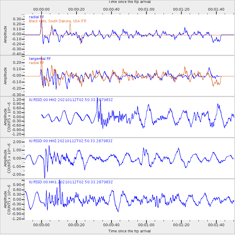
RSSD Black Hills, South Dakota, USA - Earthquake Result Viewer
*The percent match for this event was below the threshold and hence no stack was calculated.
| Earthquake location: |
Eastern Sea Of Japan |
| Earthquake latitude/longitude: |
43.7/140.0 |
| Earthquake time(UTC): |
2021/01/12 (012) 02:39:42 GMT |
| Earthquake Depth: |
211 km |
| Earthquake Magnitude: |
5.9 mww |
| Earthquake Catalog/Contributor: |
NEIC PDE/us |
|
| Network: |
IU Global Seismograph Network (GSN - IRIS/USGS) |
| Station: |
RSSD Black Hills, South Dakota, USA |
| Lat/Lon: |
44.12 N/104.04 W |
| Elevation: |
2090 m |
|
| Distance: |
75.6 deg |
| Az: |
41.954 deg |
| Baz: |
317.684 deg |
| Ray Param: |
$rayparam |
*The percent match for this event was below the threshold and hence was not used in the summary stack. |
|
| Radial Match: |
74.81193 % |
| Radial Bump: |
400 |
| Transverse Match: |
53.532257 % |
| Transverse Bump: |
400 |
| SOD ConfigId: |
23341671 |
| Insert Time: |
2021-01-26 03:54:02.976 +0000 |
| GWidth: |
2.5 |
| Max Bumps: |
400 |
| Tol: |
0.001 |
|
Signal To Noise
| Channel | StoN | STA | LTA |
| IU:RSSD:00:HHZ:20210112T02:50:33.287983Z | 3.8728943 | 9.281953E-7 | 2.396645E-7 |
| IU:RSSD:00:HH1:20210112T02:50:33.287983Z | 0.7625536 | 2.7108842E-7 | 3.5550084E-7 |
| IU:RSSD:00:HH2:20210112T02:50:33.287983Z | 2.267534 | 5.2902686E-7 | 2.3330493E-7 |
| Arrivals |
| Ps | |
| PpPs | |
| PsPs/PpSs | |


