You are here: Home > Network List > IU - Global Seismograph Network (GSN - IRIS/USGS) Stations List
> Station CCM Cathedral Cave, Missouri, USA > Earthquake Result Viewer
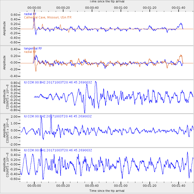
CCM Cathedral Cave, Missouri, USA - Earthquake Result Viewer
*The percent match for this event was below the threshold and hence no stack was calculated.
| Earthquake location: |
North Atlantic Ocean |
| Earthquake latitude/longitude: |
13.5/-49.3 |
| Earthquake time(UTC): |
2017/10/03 (276) 20:39:04 GMT |
| Earthquake Depth: |
10 km |
| Earthquake Magnitude: |
5.7 Mww |
| Earthquake Catalog/Contributor: |
NEIC PDE/us |
|
| Network: |
IU Global Seismograph Network (GSN - IRIS/USGS) |
| Station: |
CCM Cathedral Cave, Missouri, USA |
| Lat/Lon: |
38.06 N/91.24 W |
| Elevation: |
222 m |
|
| Distance: |
44.5 deg |
| Az: |
311.18 deg |
| Baz: |
111.938 deg |
| Ray Param: |
$rayparam |
*The percent match for this event was below the threshold and hence was not used in the summary stack. |
|
| Radial Match: |
67.420235 % |
| Radial Bump: |
400 |
| Transverse Match: |
52.989918 % |
| Transverse Bump: |
400 |
| SOD ConfigId: |
2364251 |
| Insert Time: |
2017-10-17 20:41:00.425 +0000 |
| GWidth: |
2.5 |
| Max Bumps: |
400 |
| Tol: |
0.001 |
|
Signal To Noise
| Channel | StoN | STA | LTA |
| IU:CCM:00:BHZ:20171003T20:46:45.269003Z | 3.3669684 | 5.416359E-7 | 1.6086754E-7 |
| IU:CCM:00:BH1:20171003T20:46:45.269003Z | 1.6282357 | 2.927543E-7 | 1.7979848E-7 |
| IU:CCM:00:BH2:20171003T20:46:45.269003Z | 2.7740824 | 3.0554432E-7 | 1.1014248E-7 |
| Arrivals |
| Ps | |
| PpPs | |
| PsPs/PpSs | |


