You are here: Home > Network List > TA - USArray Transportable Network (new EarthScope stations) Stations List
> Station I17K Unalakleet, AK, USA > Earthquake Result Viewer
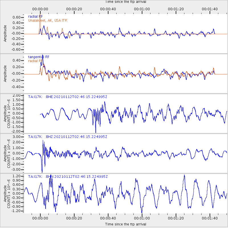
I17K Unalakleet, AK, USA - Earthquake Result Viewer
*The percent match for this event was below the threshold and hence no stack was calculated.
| Earthquake location: |
Eastern Sea Of Japan |
| Earthquake latitude/longitude: |
43.7/140.0 |
| Earthquake time(UTC): |
2021/01/12 (012) 02:39:42 GMT |
| Earthquake Depth: |
211 km |
| Earthquake Magnitude: |
5.9 mww |
| Earthquake Catalog/Contributor: |
NEIC PDE/us |
|
| Network: |
TA USArray Transportable Network (new EarthScope stations) |
| Station: |
I17K Unalakleet, AK, USA |
| Lat/Lon: |
63.89 N/160.70 W |
| Elevation: |
105 m |
|
| Distance: |
38.6 deg |
| Az: |
37.561 deg |
| Baz: |
267.497 deg |
| Ray Param: |
$rayparam |
*The percent match for this event was below the threshold and hence was not used in the summary stack. |
|
| Radial Match: |
51.97862 % |
| Radial Bump: |
391 |
| Transverse Match: |
57.337986 % |
| Transverse Bump: |
400 |
| SOD ConfigId: |
23341671 |
| Insert Time: |
2021-01-26 04:04:26.370 +0000 |
| GWidth: |
2.5 |
| Max Bumps: |
400 |
| Tol: |
0.001 |
|
Signal To Noise
| Channel | StoN | STA | LTA |
| TA:I17K: :BHZ:20210112T02:46:15.224995Z | 2.0979455 | 1.2234354E-6 | 5.8315885E-7 |
| TA:I17K: :BHN:20210112T02:46:15.224995Z | 0.8893411 | 5.089734E-7 | 5.723039E-7 |
| TA:I17K: :BHE:20210112T02:46:15.224995Z | 1.7582439 | 6.7957654E-7 | 3.865087E-7 |
| Arrivals |
| Ps | |
| PpPs | |
| PsPs/PpSs | |


