You are here: Home > Network List > TA - USArray Transportable Network (new EarthScope stations) Stations List
> Station O17K Koliganek, Bristol Bay, AK, USA > Earthquake Result Viewer
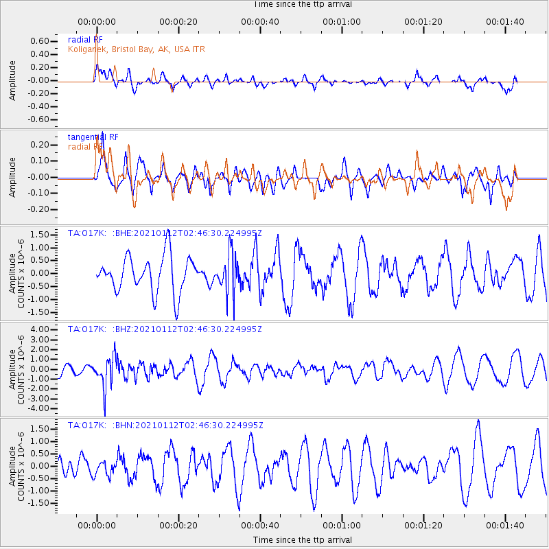
O17K Koliganek, Bristol Bay, AK, USA - Earthquake Result Viewer
*The percent match for this event was below the threshold and hence no stack was calculated.
| Earthquake location: |
Eastern Sea Of Japan |
| Earthquake latitude/longitude: |
43.7/140.0 |
| Earthquake time(UTC): |
2021/01/12 (012) 02:39:42 GMT |
| Earthquake Depth: |
211 km |
| Earthquake Magnitude: |
5.9 mww |
| Earthquake Catalog/Contributor: |
NEIC PDE/us |
|
| Network: |
TA USArray Transportable Network (new EarthScope stations) |
| Station: |
O17K Koliganek, Bristol Bay, AK, USA |
| Lat/Lon: |
59.77 N/157.09 W |
| Elevation: |
156 m |
|
| Distance: |
40.5 deg |
| Az: |
43.97 deg |
| Baz: |
275.613 deg |
| Ray Param: |
$rayparam |
*The percent match for this event was below the threshold and hence was not used in the summary stack. |
|
| Radial Match: |
46.997684 % |
| Radial Bump: |
400 |
| Transverse Match: |
50.385803 % |
| Transverse Bump: |
400 |
| SOD ConfigId: |
23341671 |
| Insert Time: |
2021-01-26 04:04:56.292 +0000 |
| GWidth: |
2.5 |
| Max Bumps: |
400 |
| Tol: |
0.001 |
|
Signal To Noise
| Channel | StoN | STA | LTA |
| TA:O17K: :BHZ:20210112T02:46:30.224995Z | 1.9947705 | 1.5324814E-6 | 7.682495E-7 |
| TA:O17K: :BHN:20210112T02:46:30.224995Z | 0.37717015 | 2.797407E-7 | 7.41683E-7 |
| TA:O17K: :BHE:20210112T02:46:30.224995Z | 1.0826145 | 7.5321856E-7 | 6.9574025E-7 |
| Arrivals |
| Ps | |
| PpPs | |
| PsPs/PpSs | |


