You are here: Home > Network List > US - United States National Seismic Network Stations List
> Station ERPA Erie, Pennsylvania, USA > Earthquake Result Viewer
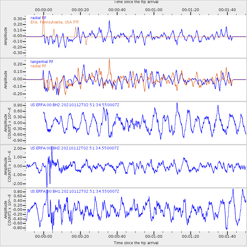
ERPA Erie, Pennsylvania, USA - Earthquake Result Viewer
*The percent match for this event was below the threshold and hence no stack was calculated.
| Earthquake location: |
Eastern Sea Of Japan |
| Earthquake latitude/longitude: |
43.7/140.0 |
| Earthquake time(UTC): |
2021/01/12 (012) 02:39:42 GMT |
| Earthquake Depth: |
211 km |
| Earthquake Magnitude: |
5.9 mww |
| Earthquake Catalog/Contributor: |
NEIC PDE/us |
|
| Network: |
US United States National Seismic Network |
| Station: |
ERPA Erie, Pennsylvania, USA |
| Lat/Lon: |
42.12 N/79.99 W |
| Elevation: |
306 m |
|
| Distance: |
87.3 deg |
| Az: |
28.594 deg |
| Baz: |
332.19 deg |
| Ray Param: |
$rayparam |
*The percent match for this event was below the threshold and hence was not used in the summary stack. |
|
| Radial Match: |
42.01209 % |
| Radial Bump: |
400 |
| Transverse Match: |
55.099293 % |
| Transverse Bump: |
400 |
| SOD ConfigId: |
23341671 |
| Insert Time: |
2021-01-26 04:07:31.369 +0000 |
| GWidth: |
2.5 |
| Max Bumps: |
400 |
| Tol: |
0.001 |
|
Signal To Noise
| Channel | StoN | STA | LTA |
| US:ERPA:00:BHZ:20210112T02:51:34.550007Z | 2.6517568 | 9.855593E-7 | 3.716628E-7 |
| US:ERPA:00:BH1:20210112T02:51:34.550007Z | 1.5058383 | 4.1577962E-7 | 2.7611173E-7 |
| US:ERPA:00:BH2:20210112T02:51:34.550007Z | 1.5658486 | 4.887534E-7 | 3.1213327E-7 |
| Arrivals |
| Ps | |
| PpPs | |
| PsPs/PpSs | |


