You are here: Home > Network List > UU - University of Utah Regional Network Stations List
> Station KNB Kanab, UT, USA > Earthquake Result Viewer
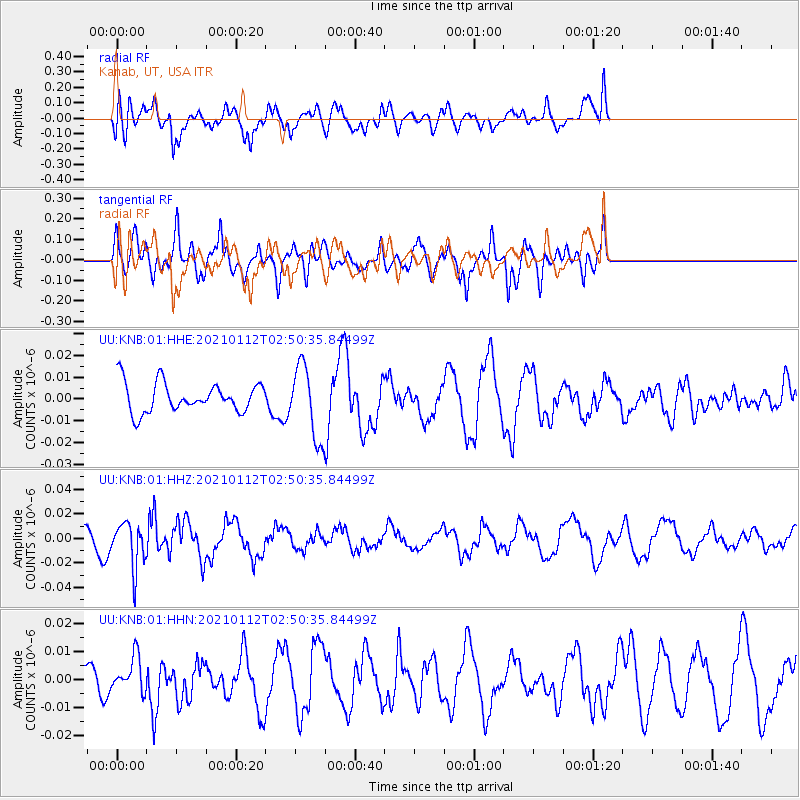
KNB Kanab, UT, USA - Earthquake Result Viewer
*The percent match for this event was below the threshold and hence no stack was calculated.
| Earthquake location: |
Eastern Sea Of Japan |
| Earthquake latitude/longitude: |
43.7/140.0 |
| Earthquake time(UTC): |
2021/01/12 (012) 02:39:42 GMT |
| Earthquake Depth: |
211 km |
| Earthquake Magnitude: |
5.9 mww |
| Earthquake Catalog/Contributor: |
NEIC PDE/us |
|
| Network: |
UU University of Utah Regional Network |
| Station: |
KNB Kanab, UT, USA |
| Lat/Lon: |
37.02 N/112.82 W |
| Elevation: |
1715 m |
|
| Distance: |
76.0 deg |
| Az: |
51.994 deg |
| Baz: |
314.442 deg |
| Ray Param: |
$rayparam |
*The percent match for this event was below the threshold and hence was not used in the summary stack. |
|
| Radial Match: |
52.331444 % |
| Radial Bump: |
400 |
| Transverse Match: |
61.704308 % |
| Transverse Bump: |
312 |
| SOD ConfigId: |
23341671 |
| Insert Time: |
2021-01-26 04:08:36.291 +0000 |
| GWidth: |
2.5 |
| Max Bumps: |
400 |
| Tol: |
0.001 |
|
Signal To Noise
| Channel | StoN | STA | LTA |
| UU:KNB:01:HHZ:20210112T02:50:35.84499Z | 2.6516058 | 1.8192198E-8 | 6.860823E-9 |
| UU:KNB:01:HHN:20210112T02:50:35.84499Z | 1.2285949 | 6.2801537E-9 | 5.1116555E-9 |
| UU:KNB:01:HHE:20210112T02:50:35.84499Z | 2.4366047 | 1.6485277E-8 | 6.765675E-9 |
| Arrivals |
| Ps | |
| PpPs | |
| PsPs/PpSs | |


