You are here: Home > Network List > US - United States National Seismic Network Stations List
> Station MSO Missoula, Montana, USA > Earthquake Result Viewer
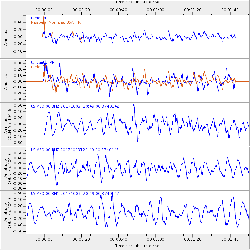
MSO Missoula, Montana, USA - Earthquake Result Viewer
*The percent match for this event was below the threshold and hence no stack was calculated.
| Earthquake location: |
North Atlantic Ocean |
| Earthquake latitude/longitude: |
13.5/-49.3 |
| Earthquake time(UTC): |
2017/10/03 (276) 20:39:04 GMT |
| Earthquake Depth: |
10 km |
| Earthquake Magnitude: |
5.7 Mww |
| Earthquake Catalog/Contributor: |
NEIC PDE/us |
|
| Network: |
US United States National Seismic Network |
| Station: |
MSO Missoula, Montana, USA |
| Lat/Lon: |
46.83 N/113.94 W |
| Elevation: |
1264 m |
|
| Distance: |
63.0 deg |
| Az: |
315.861 deg |
| Baz: |
99.329 deg |
| Ray Param: |
$rayparam |
*The percent match for this event was below the threshold and hence was not used in the summary stack. |
|
| Radial Match: |
33.472664 % |
| Radial Bump: |
400 |
| Transverse Match: |
65.64745 % |
| Transverse Bump: |
373 |
| SOD ConfigId: |
2364251 |
| Insert Time: |
2017-10-17 20:43:35.174 +0000 |
| GWidth: |
2.5 |
| Max Bumps: |
400 |
| Tol: |
0.001 |
|
Signal To Noise
| Channel | StoN | STA | LTA |
| US:MSO:00:BHZ:20171003T20:49:00.374014Z | 1.863455 | 2.92986E-7 | 1.5722729E-7 |
| US:MSO:00:BH1:20171003T20:49:00.374014Z | 0.6199522 | 1.0250436E-7 | 1.6534236E-7 |
| US:MSO:00:BH2:20171003T20:49:00.374014Z | 1.1129271 | 2.1872737E-7 | 1.965334E-7 |
| Arrivals |
| Ps | |
| PpPs | |
| PsPs/PpSs | |


