You are here: Home > Network List > UW - Pacific Northwest Regional Seismic Network Stations List
> Station IRON Crane, OR, USA > Earthquake Result Viewer
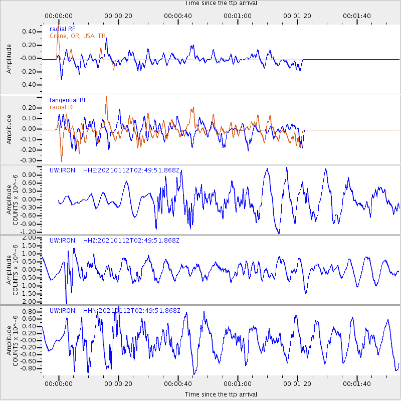
IRON Crane, OR, USA - Earthquake Result Viewer
*The percent match for this event was below the threshold and hence no stack was calculated.
| Earthquake location: |
Eastern Sea Of Japan |
| Earthquake latitude/longitude: |
43.7/140.0 |
| Earthquake time(UTC): |
2021/01/12 (012) 02:39:42 GMT |
| Earthquake Depth: |
211 km |
| Earthquake Magnitude: |
5.9 mww |
| Earthquake Catalog/Contributor: |
NEIC PDE/us |
|
| Network: |
UW Pacific Northwest Regional Seismic Network |
| Station: |
IRON Crane, OR, USA |
| Lat/Lon: |
43.36 N/118.47 W |
| Elevation: |
1226 m |
|
| Distance: |
68.6 deg |
| Az: |
50.148 deg |
| Baz: |
310.239 deg |
| Ray Param: |
$rayparam |
*The percent match for this event was below the threshold and hence was not used in the summary stack. |
|
| Radial Match: |
62.358994 % |
| Radial Bump: |
366 |
| Transverse Match: |
62.46536 % |
| Transverse Bump: |
400 |
| SOD ConfigId: |
23341671 |
| Insert Time: |
2021-01-26 04:09:20.908 +0000 |
| GWidth: |
2.5 |
| Max Bumps: |
400 |
| Tol: |
0.001 |
|
Signal To Noise
| Channel | StoN | STA | LTA |
| UW:IRON: :HHZ:20210112T02:49:51.868Z | 1.9717209 | 7.309773E-7 | 3.7073062E-7 |
| UW:IRON: :HHN:20210112T02:49:51.868Z | 1.067751 | 2.6706195E-7 | 2.5011633E-7 |
| UW:IRON: :HHE:20210112T02:49:51.868Z | 1.7238631 | 3.6273656E-7 | 2.1042074E-7 |
| Arrivals |
| Ps | |
| PpPs | |
| PsPs/PpSs | |


