You are here: Home > Network List > TA - USArray Transportable Network (new EarthScope stations) Stations List
> Station R33M Jennings River, BC, CAN > Earthquake Result Viewer
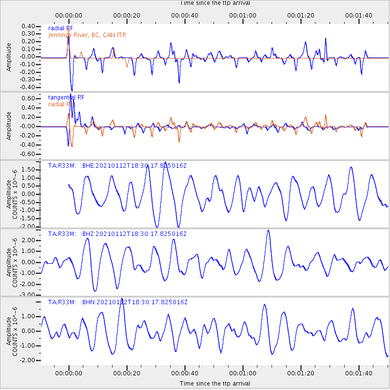
R33M Jennings River, BC, CAN - Earthquake Result Viewer
*The percent match for this event was below the threshold and hence no stack was calculated.
| Earthquake location: |
Irian Jaya, Indonesia |
| Earthquake latitude/longitude: |
-3.1/136.9 |
| Earthquake time(UTC): |
2021/01/12 (012) 18:17:32 GMT |
| Earthquake Depth: |
10 km |
| Earthquake Magnitude: |
5.9 mww |
| Earthquake Catalog/Contributor: |
NEIC PDE/us |
|
| Network: |
TA USArray Transportable Network (new EarthScope stations) |
| Station: |
R33M Jennings River, BC, CAN |
| Lat/Lon: |
59.39 N/130.97 W |
| Elevation: |
1437 m |
|
| Distance: |
93.8 deg |
| Az: |
30.825 deg |
| Baz: |
270.266 deg |
| Ray Param: |
$rayparam |
*The percent match for this event was below the threshold and hence was not used in the summary stack. |
|
| Radial Match: |
68.06264 % |
| Radial Bump: |
400 |
| Transverse Match: |
89.98474 % |
| Transverse Bump: |
392 |
| SOD ConfigId: |
23341671 |
| Insert Time: |
2021-01-26 19:25:06.709 +0000 |
| GWidth: |
2.5 |
| Max Bumps: |
400 |
| Tol: |
0.001 |
|
Signal To Noise
| Channel | StoN | STA | LTA |
| TA:R33M: :BHZ:20210112T18:30:17.825016Z | 0.5807688 | 7.811311E-7 | 1.344995E-6 |
| TA:R33M: :BHN:20210112T18:30:17.825016Z | 0.38644072 | 3.8981509E-7 | 1.0087319E-6 |
| TA:R33M: :BHE:20210112T18:30:17.825016Z | 2.2307088 | 1.5050405E-6 | 6.7469165E-7 |
| Arrivals |
| Ps | |
| PpPs | |
| PsPs/PpSs | |


