You are here: Home > Network List > WY - Yellowstone Wyoming Seismic Network Stations List
> Station YNR Norris Junction, YNP, WY, USA > Earthquake Result Viewer
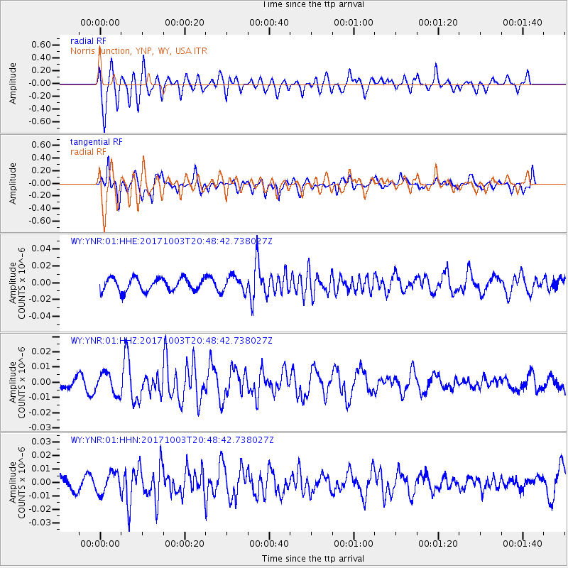
YNR Norris Junction, YNP, WY, USA - Earthquake Result Viewer
*The percent match for this event was below the threshold and hence no stack was calculated.
| Earthquake location: |
North Atlantic Ocean |
| Earthquake latitude/longitude: |
13.5/-49.3 |
| Earthquake time(UTC): |
2017/10/03 (276) 20:39:04 GMT |
| Earthquake Depth: |
10 km |
| Earthquake Magnitude: |
5.7 Mww |
| Earthquake Catalog/Contributor: |
NEIC PDE/us |
|
| Network: |
WY Yellowstone Wyoming Seismic Network |
| Station: |
YNR Norris Junction, YNP, WY, USA |
| Lat/Lon: |
44.72 N/110.68 W |
| Elevation: |
2336 m |
|
| Distance: |
60.4 deg |
| Az: |
313.949 deg |
| Baz: |
100.752 deg |
| Ray Param: |
$rayparam |
*The percent match for this event was below the threshold and hence was not used in the summary stack. |
|
| Radial Match: |
62.150364 % |
| Radial Bump: |
400 |
| Transverse Match: |
78.836876 % |
| Transverse Bump: |
400 |
| SOD ConfigId: |
2364251 |
| Insert Time: |
2017-10-17 20:44:29.160 +0000 |
| GWidth: |
2.5 |
| Max Bumps: |
400 |
| Tol: |
0.001 |
|
Signal To Noise
| Channel | StoN | STA | LTA |
| WY:YNR:01:HHZ:20171003T20:48:42.738027Z | 2.526036 | 6.921791E-9 | 2.7401792E-9 |
| WY:YNR:01:HHN:20171003T20:48:42.738027Z | 1.8627617 | 7.865565E-9 | 4.2225285E-9 |
| WY:YNR:01:HHE:20171003T20:48:42.738027Z | 1.1677564 | 8.970946E-9 | 7.682206E-9 |
| Arrivals |
| Ps | |
| PpPs | |
| PsPs/PpSs | |


