You are here: Home > Network List > AV - Alaska Volcano Observatory Stations List
> Station PLBL Mt. Peulik Volcano, Alaska > Earthquake Result Viewer
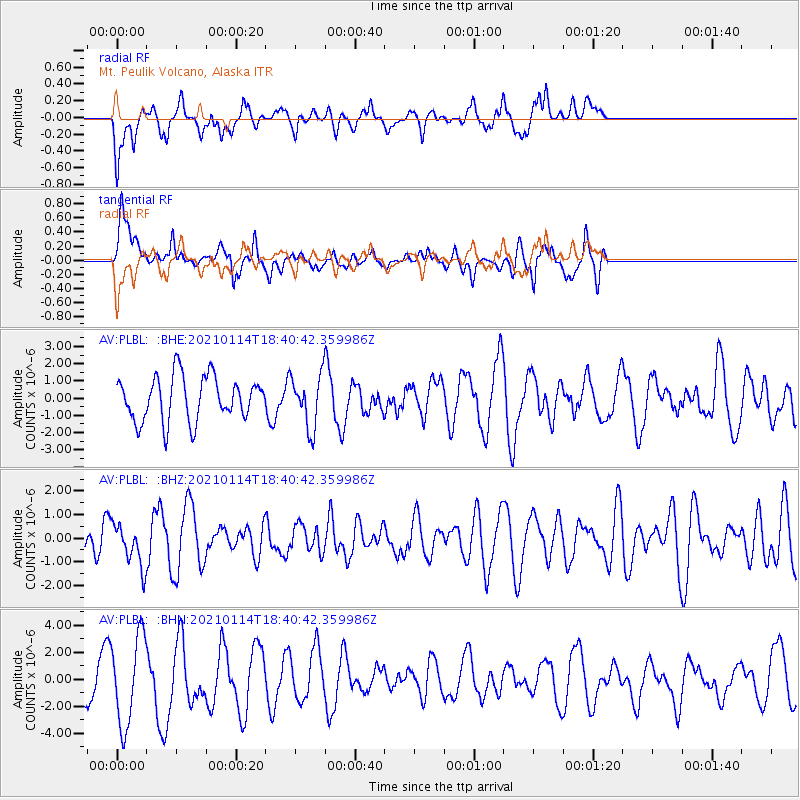
PLBL Mt. Peulik Volcano, Alaska - Earthquake Result Viewer
*The percent match for this event was below the threshold and hence no stack was calculated.
| Earthquake location: |
Sulawesi, Indonesia |
| Earthquake latitude/longitude: |
-3.0/118.9 |
| Earthquake time(UTC): |
2021/01/14 (014) 18:28:18 GMT |
| Earthquake Depth: |
18 km |
| Earthquake Magnitude: |
6.2 mww |
| Earthquake Catalog/Contributor: |
NEIC PDE/us |
|
| Network: |
AV Alaska Volcano Observatory |
| Station: |
PLBL Mt. Peulik Volcano, Alaska |
| Lat/Lon: |
57.70 N/156.82 W |
| Elevation: |
461 m |
|
| Distance: |
89.4 deg |
| Az: |
32.294 deg |
| Baz: |
263.552 deg |
| Ray Param: |
$rayparam |
*The percent match for this event was below the threshold and hence was not used in the summary stack. |
|
| Radial Match: |
52.42691 % |
| Radial Bump: |
392 |
| Transverse Match: |
48.283 % |
| Transverse Bump: |
327 |
| SOD ConfigId: |
23341671 |
| Insert Time: |
2021-01-28 19:33:32.670 +0000 |
| GWidth: |
2.5 |
| Max Bumps: |
400 |
| Tol: |
0.001 |
|
Signal To Noise
| Channel | StoN | STA | LTA |
| AV:PLBL: :BHZ:20210114T18:40:42.359986Z | 1.4983231 | 8.860446E-7 | 5.913575E-7 |
| AV:PLBL: :BHN:20210114T18:40:42.359986Z | 2.5712287 | 3.2849887E-6 | 1.2775948E-6 |
| AV:PLBL: :BHE:20210114T18:40:42.359986Z | 1.1894137 | 1.5225226E-6 | 1.2800614E-6 |
| Arrivals |
| Ps | |
| PpPs | |
| PsPs/PpSs | |


