You are here: Home > Network List > G - GEOSCOPE Stations List
> Station ATD Arta Cave - Arta, Republic of Djibouti > Earthquake Result Viewer
ATD Arta Cave - Arta, Republic of Djibouti - Earthquake Result Viewer
| Earthquake location: |
Sulawesi, Indonesia |
| Earthquake latitude/longitude: |
-3.0/118.9 |
| Earthquake time(UTC): |
2021/01/14 (014) 18:28:18 GMT |
| Earthquake Depth: |
18 km |
| Earthquake Magnitude: |
6.2 mww |
| Earthquake Catalog/Contributor: |
NEIC PDE/us |
|
| Network: |
G GEOSCOPE |
| Station: |
ATD Arta Cave - Arta, Republic of Djibouti |
| Lat/Lon: |
11.53 N/42.85 E |
| Elevation: |
610 m |
|
| Distance: |
77.0 deg |
| Az: |
282.484 deg |
| Baz: |
95.817 deg |
| Ray Param: |
0.050611142 |
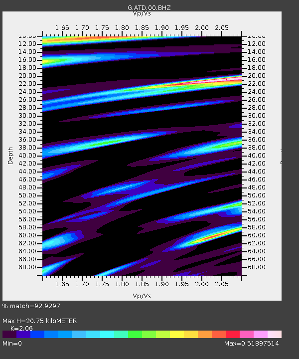
| Estimated Moho Depth: |
20.75 km |
| Estimated Crust Vp/Vs: |
2.06 |
| Assumed Crust Vp: |
6.375 km/s |
| Estimated Crust Vs: |
3.095 km/s |
| Estimated Crust Poisson's Ratio: |
0.35 |
|
| Radial Match: |
92.9297 % |
| Radial Bump: |
362 |
| Transverse Match: |
85.94268 % |
| Transverse Bump: |
400 |
| SOD ConfigId: |
23341671 |
| Insert Time: |
2021-01-28 19:34:13.306 +0000 |
| GWidth: |
2.5 |
| Max Bumps: |
400 |
| Tol: |
0.001 |
|
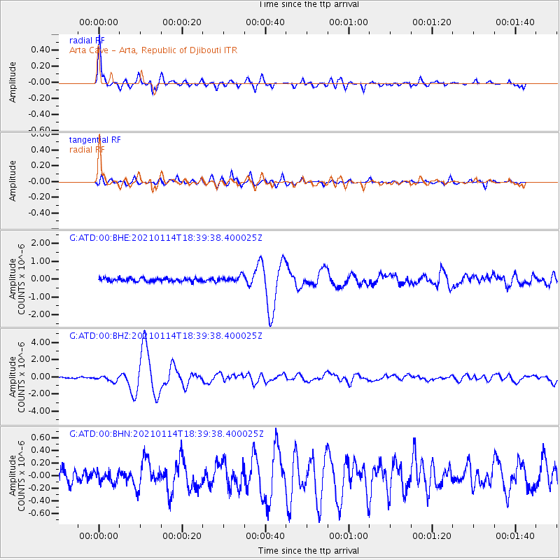
Signal To Noise
| Channel | StoN | STA | LTA |
| G:ATD:00:BHZ:20210114T18:39:38.400025Z | 5.225864 | 3.0808184E-7 | 5.8953287E-8 |
| G:ATD:00:BHN:20210114T18:39:38.400025Z | 0.80379415 | 8.411876E-8 | 1.0465212E-7 |
| G:ATD:00:BHE:20210114T18:39:38.400025Z | 1.8494971 | 1.7529146E-7 | 9.47779E-8 |
| Arrivals |
| Ps | 3.5 SECOND |
| PpPs | 9.7 SECOND |
| PsPs/PpSs | 13 SECOND |


