You are here: Home > Network List > GO - National Seismic Network of Georgia Stations List
> Station TBLG Delisi, Georgia > Earthquake Result Viewer
TBLG Delisi, Georgia - Earthquake Result Viewer

| Earthquake location: |
Sulawesi, Indonesia |
| Earthquake latitude/longitude: |
-3.0/118.9 |
| Earthquake time(UTC): |
2021/01/14 (014) 18:28:18 GMT |
| Earthquake Depth: |
18 km |
| Earthquake Magnitude: |
6.2 mww |
| Earthquake Catalog/Contributor: |
NEIC PDE/us |
|
| Network: |
GO National Seismic Network of Georgia |
| Station: |
TBLG Delisi, Georgia |
| Lat/Lon: |
41.73 N/44.74 E |
| Elevation: |
510 m |
|
| Distance: |
80.3 deg |
| Az: |
313.055 deg |
| Baz: |
102.865 deg |
| Ray Param: |
0.048388064 |
| Estimated Moho Depth: |
43.25 km |
| Estimated Crust Vp/Vs: |
1.83 |
| Assumed Crust Vp: |
6.291 km/s |
| Estimated Crust Vs: |
3.433 km/s |
| Estimated Crust Poisson's Ratio: |
0.29 |
|
| Radial Match: |
86.9457 % |
| Radial Bump: |
355 |
| Transverse Match: |
82.063065 % |
| Transverse Bump: |
400 |
| SOD ConfigId: |
23341671 |
| Insert Time: |
2021-01-28 19:34:38.177 +0000 |
| GWidth: |
2.5 |
| Max Bumps: |
400 |
| Tol: |
0.001 |
|
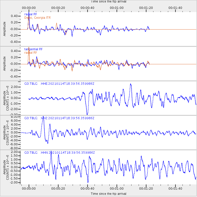
Signal To Noise
| Channel | StoN | STA | LTA |
| GO:TBLG: :HHZ:20210114T18:39:56.359986Z | 4.8741736 | 6.0157384E-7 | 1.2342068E-7 |
| GO:TBLG: :HHN:20210114T18:39:56.359986Z | 1.5982317 | 1.4192564E-7 | 8.880167E-8 |
| GO:TBLG: :HHE:20210114T18:39:56.359986Z | 1.5176742 | 1.9045639E-7 | 1.2549226E-7 |
| Arrivals |
| Ps | 5.9 SECOND |
| PpPs | 19 SECOND |
| PsPs/PpSs | 25 SECOND |


