You are here: Home > Network List > IU - Global Seismograph Network (GSN - IRIS/USGS) Stations List
> Station KBL Kabul, Afghanistan > Earthquake Result Viewer
KBL Kabul, Afghanistan - Earthquake Result Viewer
| Earthquake location: |
Sulawesi, Indonesia |
| Earthquake latitude/longitude: |
-3.0/118.9 |
| Earthquake time(UTC): |
2021/01/14 (014) 18:28:18 GMT |
| Earthquake Depth: |
18 km |
| Earthquake Magnitude: |
6.2 mww |
| Earthquake Catalog/Contributor: |
NEIC PDE/us |
|
| Network: |
IU Global Seismograph Network (GSN - IRIS/USGS) |
| Station: |
KBL Kabul, Afghanistan |
| Lat/Lon: |
34.54 N/69.04 E |
| Elevation: |
1920 m |
|
| Distance: |
59.9 deg |
| Az: |
313.13 deg |
| Baz: |
118.008 deg |
| Ray Param: |
0.061877165 |
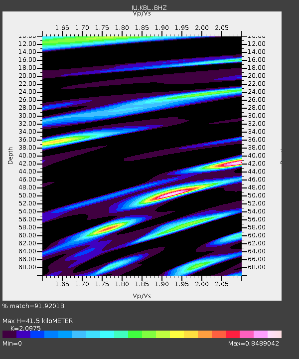
| Estimated Moho Depth: |
41.5 km |
| Estimated Crust Vp/Vs: |
2.10 |
| Assumed Crust Vp: |
6.641 km/s |
| Estimated Crust Vs: |
3.166 km/s |
| Estimated Crust Poisson's Ratio: |
0.35 |
|
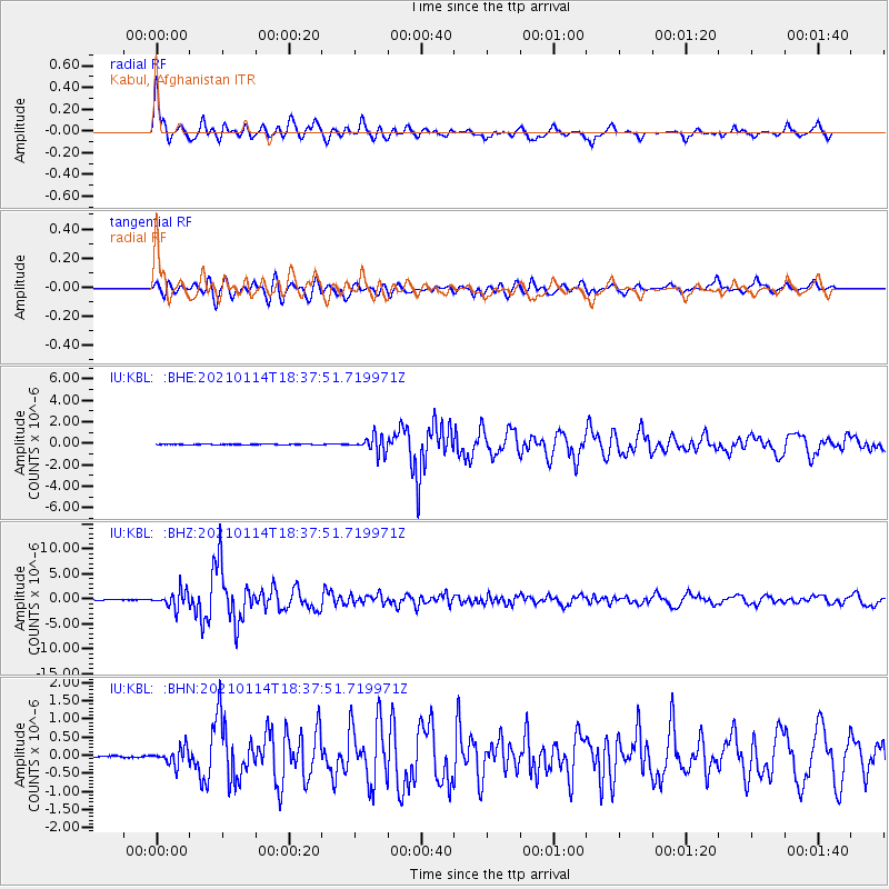
| Radial Match: |
91.92018 % |
| Radial Bump: |
400 |
| Transverse Match: |
87.375916 % |
| Transverse Bump: |
400 |
| SOD ConfigId: |
23341671 |
| Insert Time: |
2021-01-28 19:35:32.839 +0000 |
| GWidth: |
2.5 |
| Max Bumps: |
400 |
| Tol: |
0.001 |
|
Signal To Noise
| Channel | StoN | STA | LTA |
| IU:KBL: :BHZ:20210114T18:37:51.719971Z | 36.81156 | 1.7004459E-6 | 4.6193257E-8 |
| IU:KBL: :BHN:20210114T18:37:51.719971Z | 8.249063 | 2.3382543E-7 | 2.83457E-8 |
| IU:KBL: :BHE:20210114T18:37:51.719971Z | 31.817211 | 7.614507E-7 | 2.3932037E-8 |
| Arrivals |
| Ps | 7.2 SECOND |
| PpPs | 19 SECOND |
| PsPs/PpSs | 26 SECOND |


