You are here: Home > Network List > TA - USArray Transportable Network (new EarthScope stations) Stations List
> Station F14K Arctic Creek, AK, USA > Earthquake Result Viewer
F14K Arctic Creek, AK, USA - Earthquake Result Viewer
| Earthquake location: |
Sulawesi, Indonesia |
| Earthquake latitude/longitude: |
-3.0/118.9 |
| Earthquake time(UTC): |
2021/01/14 (014) 18:28:18 GMT |
| Earthquake Depth: |
18 km |
| Earthquake Magnitude: |
6.2 mww |
| Earthquake Catalog/Contributor: |
NEIC PDE/us |
|
| Network: |
TA USArray Transportable Network (new EarthScope stations) |
| Station: |
F14K Arctic Creek, AK, USA |
| Lat/Lon: |
65.47 N/166.33 W |
| Elevation: |
266 m |
|
| Distance: |
86.4 deg |
| Az: |
23.797 deg |
| Baz: |
254.872 deg |
| Ray Param: |
0.044047777 |
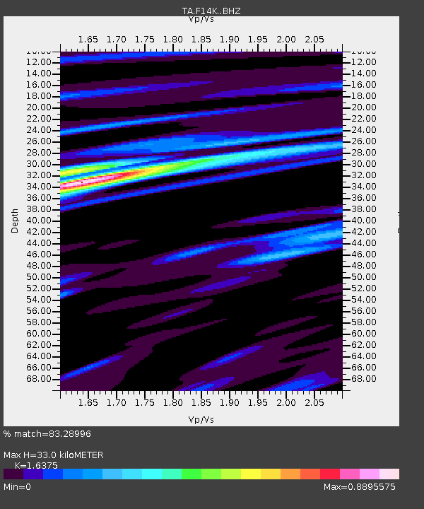
| Estimated Moho Depth: |
33.0 km |
| Estimated Crust Vp/Vs: |
1.64 |
| Assumed Crust Vp: |
6.307 km/s |
| Estimated Crust Vs: |
3.851 km/s |
| Estimated Crust Poisson's Ratio: |
0.20 |
|
| Radial Match: |
83.28996 % |
| Radial Bump: |
400 |
| Transverse Match: |
71.63201 % |
| Transverse Bump: |
400 |
| SOD ConfigId: |
23341671 |
| Insert Time: |
2021-01-28 19:38:04.299 +0000 |
| GWidth: |
2.5 |
| Max Bumps: |
400 |
| Tol: |
0.001 |
|

Signal To Noise
| Channel | StoN | STA | LTA |
| TA:F14K: :BHZ:20210114T18:40:27.974976Z | 4.006989 | 1.0981446E-6 | 2.7405733E-7 |
| TA:F14K: :BHN:20210114T18:40:27.974976Z | 1.9936718 | 3.260134E-7 | 1.6352412E-7 |
| TA:F14K: :BHE:20210114T18:40:27.974976Z | 3.1149032 | 3.6010567E-7 | 1.1560734E-7 |
| Arrivals |
| Ps | 3.4 SECOND |
| PpPs | 13 SECOND |
| PsPs/PpSs | 17 SECOND |


