You are here: Home > Network List > AK - Alaska Regional Network Stations List
> Station G19K Purcell Mountains, AK, USA > Earthquake Result Viewer
G19K Purcell Mountains, AK, USA - Earthquake Result Viewer
| Earthquake location: |
Off Coast Of Chiapas, Mexico |
| Earthquake latitude/longitude: |
13.9/-92.1 |
| Earthquake time(UTC): |
2021/01/15 (015) 16:10:51 GMT |
| Earthquake Depth: |
10 km |
| Earthquake Magnitude: |
5.9 mww |
| Earthquake Catalog/Contributor: |
NEIC PDE/us |
|
| Network: |
AK Alaska Regional Network |
| Station: |
G19K Purcell Mountains, AK, USA |
| Lat/Lon: |
66.14 N/157.09 W |
| Elevation: |
391 m |
|
| Distance: |
67.4 deg |
| Az: |
336.459 deg |
| Baz: |
107.525 deg |
| Ray Param: |
0.057024725 |
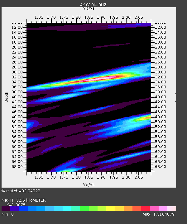
| Estimated Moho Depth: |
32.5 km |
| Estimated Crust Vp/Vs: |
1.89 |
| Assumed Crust Vp: |
6.577 km/s |
| Estimated Crust Vs: |
3.484 km/s |
| Estimated Crust Poisson's Ratio: |
0.30 |
|
| Radial Match: |
82.94322 % |
| Radial Bump: |
334 |
| Transverse Match: |
60.767757 % |
| Transverse Bump: |
400 |
| SOD ConfigId: |
23341671 |
| Insert Time: |
2021-01-29 17:13:54.434 +0000 |
| GWidth: |
2.5 |
| Max Bumps: |
400 |
| Tol: |
0.001 |
|

Signal To Noise
| Channel | StoN | STA | LTA |
| AK:G19K: :BHZ:20210115T16:21:15.320013Z | 2.033059 | 8.989457E-7 | 4.421641E-7 |
| AK:G19K: :BHN:20210115T16:21:15.320013Z | 1.384243 | 6.0251193E-7 | 4.3526455E-7 |
| AK:G19K: :BHE:20210115T16:21:15.320013Z | 1.2321757 | 3.308934E-7 | 2.68544E-7 |
| Arrivals |
| Ps | 4.6 SECOND |
| PpPs | 14 SECOND |
| PsPs/PpSs | 18 SECOND |


