You are here: Home > Network List > TA - USArray Transportable Network (new EarthScope stations) Stations List
> Station I17K Unalakleet, AK, USA > Earthquake Result Viewer
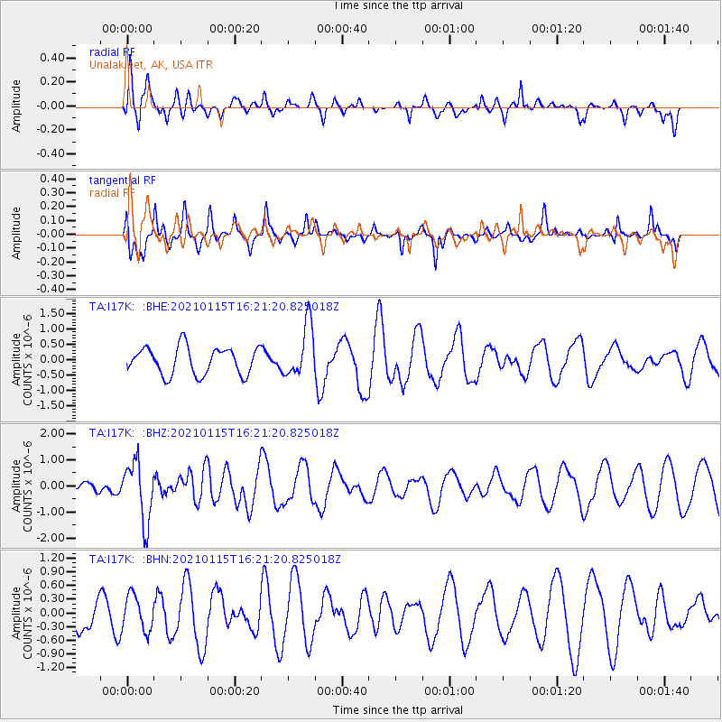
I17K Unalakleet, AK, USA - Earthquake Result Viewer
*The percent match for this event was below the threshold and hence no stack was calculated.
| Earthquake location: |
Off Coast Of Chiapas, Mexico |
| Earthquake latitude/longitude: |
13.9/-92.1 |
| Earthquake time(UTC): |
2021/01/15 (015) 16:10:51 GMT |
| Earthquake Depth: |
10 km |
| Earthquake Magnitude: |
5.9 mww |
| Earthquake Catalog/Contributor: |
NEIC PDE/us |
|
| Network: |
TA USArray Transportable Network (new EarthScope stations) |
| Station: |
I17K Unalakleet, AK, USA |
| Lat/Lon: |
63.89 N/160.70 W |
| Elevation: |
105 m |
|
| Distance: |
68.2 deg |
| Az: |
333.661 deg |
| Baz: |
103.199 deg |
| Ray Param: |
$rayparam |
*The percent match for this event was below the threshold and hence was not used in the summary stack. |
|
| Radial Match: |
39.33161 % |
| Radial Bump: |
383 |
| Transverse Match: |
58.36509 % |
| Transverse Bump: |
281 |
| SOD ConfigId: |
23341671 |
| Insert Time: |
2021-01-29 17:25:02.020 +0000 |
| GWidth: |
2.5 |
| Max Bumps: |
400 |
| Tol: |
0.001 |
|
Signal To Noise
| Channel | StoN | STA | LTA |
| TA:I17K: :BHZ:20210115T16:21:20.825018Z | 3.2599275 | 1.1423112E-6 | 3.5041003E-7 |
| TA:I17K: :BHN:20210115T16:21:20.825018Z | 0.64437276 | 3.8839198E-7 | 6.0274425E-7 |
| TA:I17K: :BHE:20210115T16:21:20.825018Z | 1.9527811 | 8.641749E-7 | 4.4253548E-7 |
| Arrivals |
| Ps | |
| PpPs | |
| PsPs/PpSs | |


