You are here: Home > Network List > TA - USArray Transportable Network (new EarthScope stations) Stations List
> Station O17K Koliganek, Bristol Bay, AK, USA > Earthquake Result Viewer
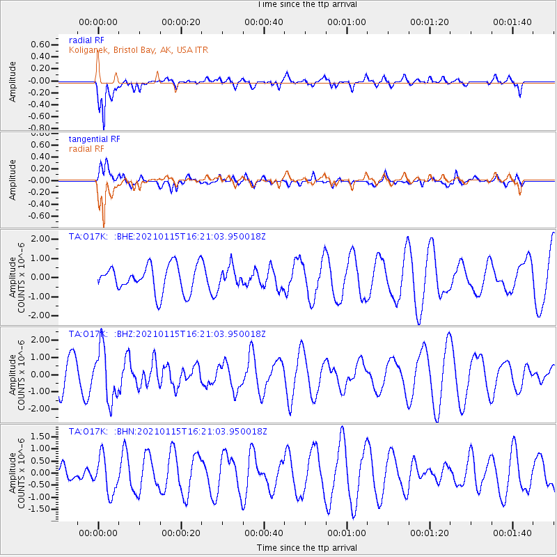
O17K Koliganek, Bristol Bay, AK, USA - Earthquake Result Viewer
*The percent match for this event was below the threshold and hence no stack was calculated.
| Earthquake location: |
Off Coast Of Chiapas, Mexico |
| Earthquake latitude/longitude: |
13.9/-92.1 |
| Earthquake time(UTC): |
2021/01/15 (015) 16:10:51 GMT |
| Earthquake Depth: |
10 km |
| Earthquake Magnitude: |
5.9 mww |
| Earthquake Catalog/Contributor: |
NEIC PDE/us |
|
| Network: |
TA USArray Transportable Network (new EarthScope stations) |
| Station: |
O17K Koliganek, Bristol Bay, AK, USA |
| Lat/Lon: |
59.77 N/157.09 W |
| Elevation: |
156 m |
|
| Distance: |
65.6 deg |
| Az: |
329.759 deg |
| Baz: |
104.839 deg |
| Ray Param: |
$rayparam |
*The percent match for this event was below the threshold and hence was not used in the summary stack. |
|
| Radial Match: |
76.84463 % |
| Radial Bump: |
400 |
| Transverse Match: |
45.1814 % |
| Transverse Bump: |
400 |
| SOD ConfigId: |
23341671 |
| Insert Time: |
2021-01-29 17:25:20.442 +0000 |
| GWidth: |
2.5 |
| Max Bumps: |
400 |
| Tol: |
0.001 |
|
Signal To Noise
| Channel | StoN | STA | LTA |
| TA:O17K: :BHZ:20210115T16:21:03.950018Z | 1.8916674 | 1.5929203E-6 | 8.420721E-7 |
| TA:O17K: :BHN:20210115T16:21:03.950018Z | 1.6260912 | 7.8154756E-7 | 4.806296E-7 |
| TA:O17K: :BHE:20210115T16:21:03.950018Z | 0.6983252 | 4.900473E-7 | 7.017465E-7 |
| Arrivals |
| Ps | |
| PpPs | |
| PsPs/PpSs | |


