You are here: Home > Network List > US - United States National Seismic Network Stations List
> Station HAWA Hanford, Washington, USA > Earthquake Result Viewer
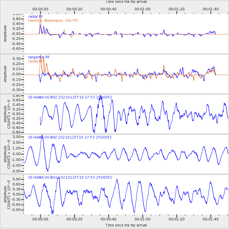
HAWA Hanford, Washington, USA - Earthquake Result Viewer
*The percent match for this event was below the threshold and hence no stack was calculated.
| Earthquake location: |
Off Coast Of Chiapas, Mexico |
| Earthquake latitude/longitude: |
13.9/-92.1 |
| Earthquake time(UTC): |
2021/01/15 (015) 16:10:51 GMT |
| Earthquake Depth: |
10 km |
| Earthquake Magnitude: |
5.9 mww |
| Earthquake Catalog/Contributor: |
NEIC PDE/us |
|
| Network: |
US United States National Seismic Network |
| Station: |
HAWA Hanford, Washington, USA |
| Lat/Lon: |
46.39 N/119.53 W |
| Elevation: |
364 m |
|
| Distance: |
39.8 deg |
| Az: |
330.08 deg |
| Baz: |
135.589 deg |
| Ray Param: |
$rayparam |
*The percent match for this event was below the threshold and hence was not used in the summary stack. |
|
| Radial Match: |
62.85745 % |
| Radial Bump: |
400 |
| Transverse Match: |
55.54513 % |
| Transverse Bump: |
400 |
| SOD ConfigId: |
23341671 |
| Insert Time: |
2021-01-29 17:26:20.053 +0000 |
| GWidth: |
2.5 |
| Max Bumps: |
400 |
| Tol: |
0.001 |
|
Signal To Noise
| Channel | StoN | STA | LTA |
| US:HAWA:00:BHZ:20210115T16:17:53.250005Z | 2.8572373 | 2.078347E-6 | 7.2739743E-7 |
| US:HAWA:00:BH1:20210115T16:17:53.250005Z | 1.2613257 | 4.5737124E-7 | 3.6261153E-7 |
| US:HAWA:00:BH2:20210115T16:17:53.250005Z | 1.4671851 | 4.7456794E-7 | 3.234547E-7 |
| Arrivals |
| Ps | |
| PpPs | |
| PsPs/PpSs | |


