You are here: Home > Network List > US - United States National Seismic Network Stations List
> Station LAO LASA Array, Montana, USA > Earthquake Result Viewer
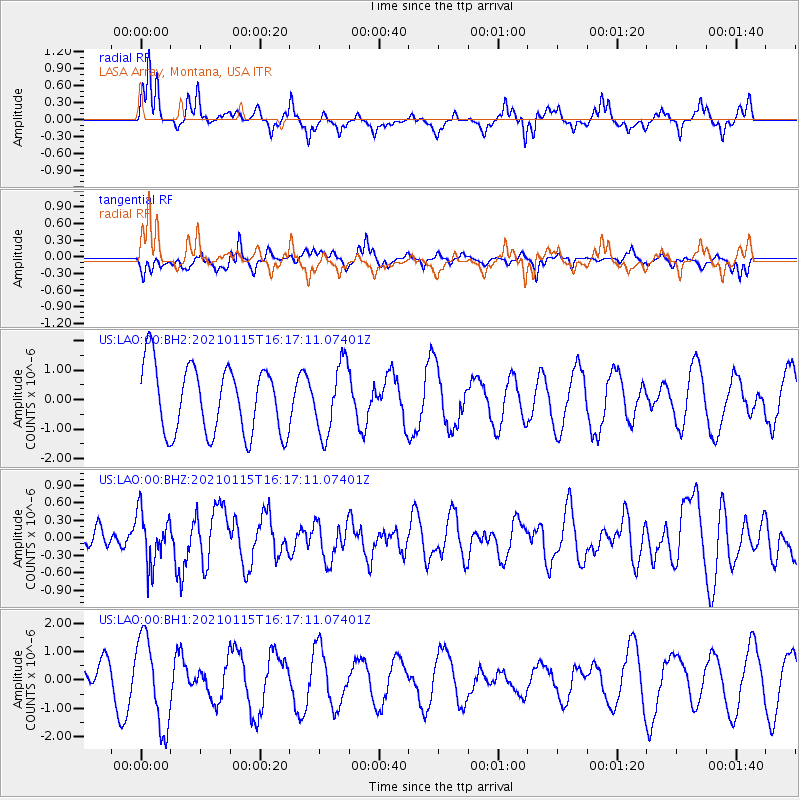
LAO LASA Array, Montana, USA - Earthquake Result Viewer
*The percent match for this event was below the threshold and hence no stack was calculated.
| Earthquake location: |
Off Coast Of Chiapas, Mexico |
| Earthquake latitude/longitude: |
13.9/-92.1 |
| Earthquake time(UTC): |
2021/01/15 (015) 16:10:51 GMT |
| Earthquake Depth: |
10 km |
| Earthquake Magnitude: |
5.9 mww |
| Earthquake Catalog/Contributor: |
NEIC PDE/us |
|
| Network: |
US United States National Seismic Network |
| Station: |
LAO LASA Array, Montana, USA |
| Lat/Lon: |
46.69 N/106.22 W |
| Elevation: |
902 m |
|
| Distance: |
34.8 deg |
| Az: |
342.862 deg |
| Baz: |
155.438 deg |
| Ray Param: |
$rayparam |
*The percent match for this event was below the threshold and hence was not used in the summary stack. |
|
| Radial Match: |
59.27788 % |
| Radial Bump: |
307 |
| Transverse Match: |
48.671196 % |
| Transverse Bump: |
400 |
| SOD ConfigId: |
23341671 |
| Insert Time: |
2021-01-29 17:26:22.873 +0000 |
| GWidth: |
2.5 |
| Max Bumps: |
400 |
| Tol: |
0.001 |
|
Signal To Noise
| Channel | StoN | STA | LTA |
| US:LAO:00:BHZ:20210115T16:17:11.07401Z | 1.4213752 | 4.4295646E-7 | 3.1163935E-7 |
| US:LAO:00:BH1:20210115T16:17:11.07401Z | 2.698371 | 1.5628833E-6 | 5.791951E-7 |
| US:LAO:00:BH2:20210115T16:17:11.07401Z | 1.0294645 | 1.1804133E-6 | 1.1466285E-6 |
| Arrivals |
| Ps | |
| PpPs | |
| PsPs/PpSs | |


