You are here: Home > Network List > US - United States National Seismic Network Stations List
> Station MNTX Cornudas Mountains, Texas, USA > Earthquake Result Viewer
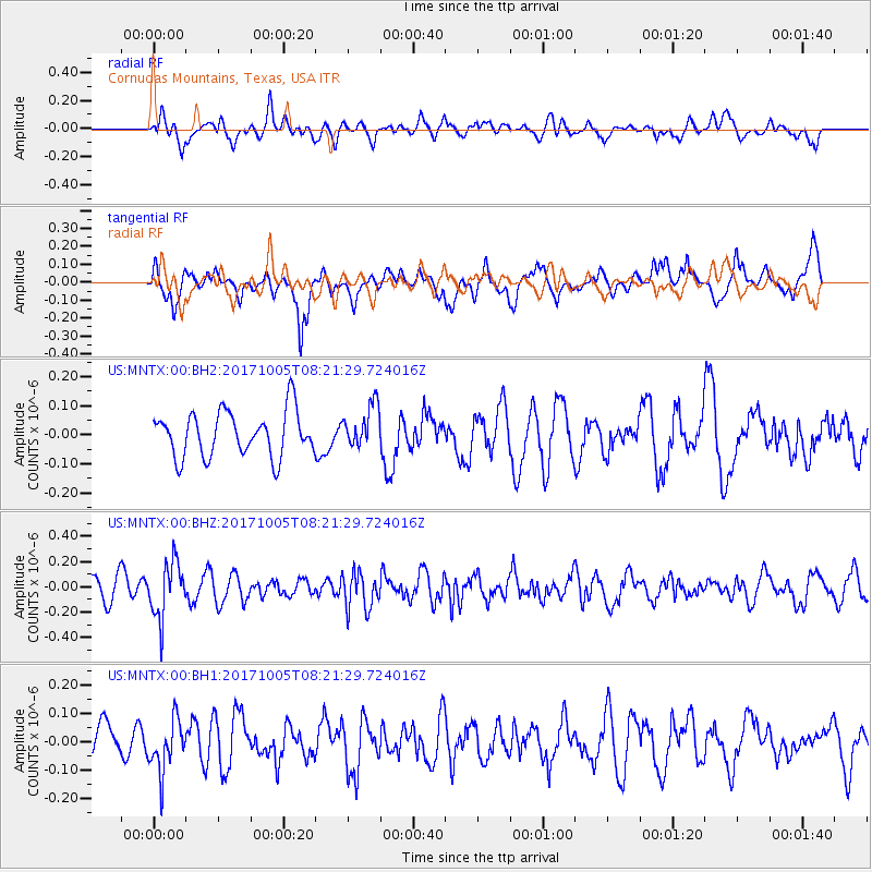
MNTX Cornudas Mountains, Texas, USA - Earthquake Result Viewer
*The percent match for this event was below the threshold and hence no stack was calculated.
| Earthquake location: |
Northern Chile |
| Earthquake latitude/longitude: |
-22.4/-68.6 |
| Earthquake time(UTC): |
2017/10/05 (278) 08:11:36 GMT |
| Earthquake Depth: |
113 km |
| Earthquake Magnitude: |
5.4 Mww |
| Earthquake Catalog/Contributor: |
NEIC PDE/us |
|
| Network: |
US United States National Seismic Network |
| Station: |
MNTX Cornudas Mountains, Texas, USA |
| Lat/Lon: |
31.70 N/105.38 W |
| Elevation: |
404 m |
|
| Distance: |
64.3 deg |
| Az: |
325.482 deg |
| Baz: |
142.036 deg |
| Ray Param: |
$rayparam |
*The percent match for this event was below the threshold and hence was not used in the summary stack. |
|
| Radial Match: |
47.150787 % |
| Radial Bump: |
400 |
| Transverse Match: |
60.828384 % |
| Transverse Bump: |
400 |
| SOD ConfigId: |
2364251 |
| Insert Time: |
2017-10-19 08:18:53.275 +0000 |
| GWidth: |
2.5 |
| Max Bumps: |
400 |
| Tol: |
0.001 |
|
Signal To Noise
| Channel | StoN | STA | LTA |
| US:MNTX:00:BHZ:20171005T08:21:29.724016Z | 3.3561752 | 2.1790048E-7 | 6.492524E-8 |
| US:MNTX:00:BH1:20171005T08:21:29.724016Z | 1.5142614 | 9.080892E-8 | 5.996912E-8 |
| US:MNTX:00:BH2:20171005T08:21:29.724016Z | 0.9487389 | 7.3205335E-8 | 7.716068E-8 |
| Arrivals |
| Ps | |
| PpPs | |
| PsPs/PpSs | |


