You are here: Home > Network List > TA - USArray Transportable Network (new EarthScope stations) Stations List
> Station G16K Koyuk River, AK, USA > Earthquake Result Viewer
G16K Koyuk River, AK, USA - Earthquake Result Viewer

| Earthquake location: |
Southern Iran |
| Earthquake latitude/longitude: |
26.9/55.2 |
| Earthquake time(UTC): |
2021/01/15 (015) 21:31:04 GMT |
| Earthquake Depth: |
8.0 km |
| Earthquake Magnitude: |
5.5 mww |
| Earthquake Catalog/Contributor: |
NEIC PDE/us |
|
| Network: |
TA USArray Transportable Network (new EarthScope stations) |
| Station: |
G16K Koyuk River, AK, USA |
| Lat/Lon: |
65.39 N/162.35 W |
| Elevation: |
169 m |
|
| Distance: |
83.5 deg |
| Az: |
14.878 deg |
| Baz: |
326.804 deg |
| Ray Param: |
0.046128158 |
| Estimated Moho Depth: |
10.75 km |
| Estimated Crust Vp/Vs: |
1.60 |
| Assumed Crust Vp: |
6.276 km/s |
| Estimated Crust Vs: |
3.922 km/s |
| Estimated Crust Poisson's Ratio: |
0.18 |
|
| Radial Match: |
84.57562 % |
| Radial Bump: |
360 |
| Transverse Match: |
71.810814 % |
| Transverse Bump: |
272 |
| SOD ConfigId: |
23341671 |
| Insert Time: |
2021-01-29 22:38:51.220 +0000 |
| GWidth: |
2.5 |
| Max Bumps: |
400 |
| Tol: |
0.001 |
|
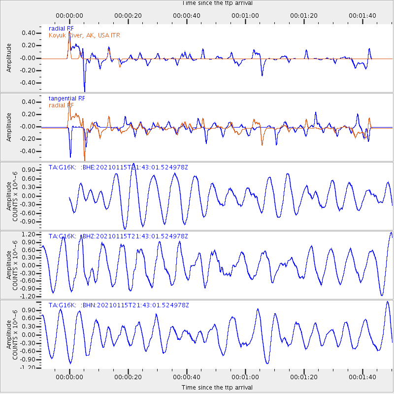
Signal To Noise
| Channel | StoN | STA | LTA |
| TA:G16K: :BHZ:20210115T21:43:01.524978Z | 1.9976215 | 7.29312E-7 | 3.6509016E-7 |
| TA:G16K: :BHN:20210115T21:43:01.524978Z | 2.2438366 | 6.8404324E-7 | 3.048543E-7 |
| TA:G16K: :BHE:20210115T21:43:01.524978Z | 1.074788 | 5.6053216E-7 | 5.215281E-7 |
| Arrivals |
| Ps | 1.1 SECOND |
| PpPs | 4.3 SECOND |
| PsPs/PpSs | 5.4 SECOND |


