You are here: Home > Network List > TA - USArray Transportable Network (new EarthScope stations) Stations List
> Station R33M Jennings River, BC, CAN > Earthquake Result Viewer
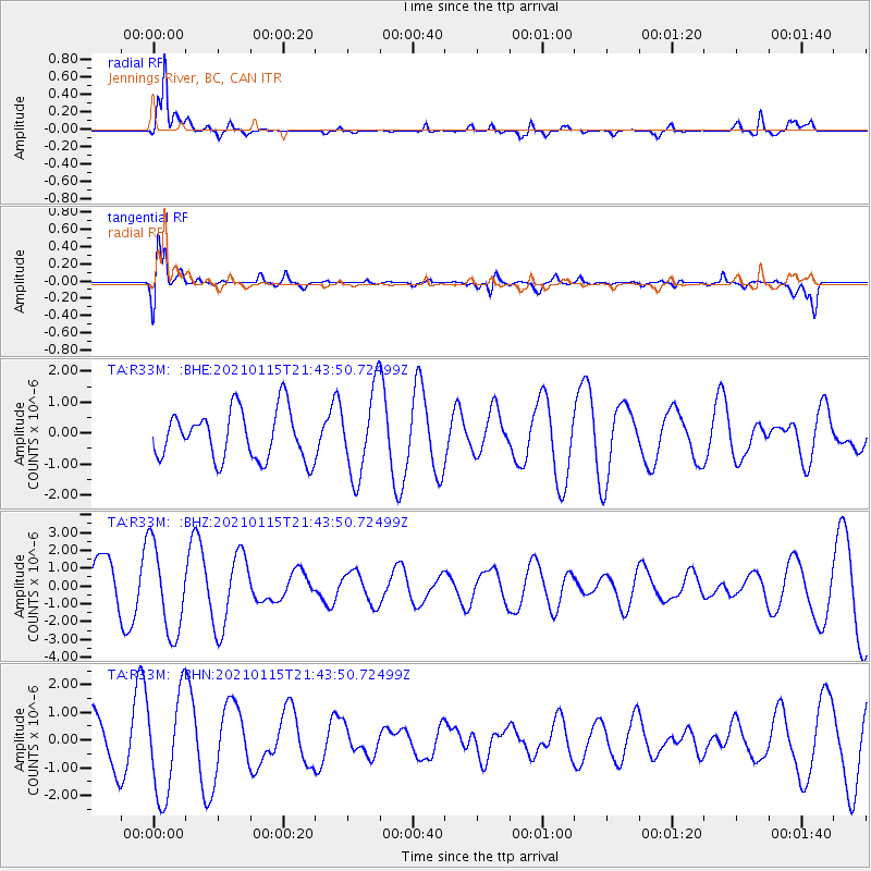
R33M Jennings River, BC, CAN - Earthquake Result Viewer
*The percent match for this event was below the threshold and hence no stack was calculated.
| Earthquake location: |
Southern Iran |
| Earthquake latitude/longitude: |
26.9/55.2 |
| Earthquake time(UTC): |
2021/01/15 (015) 21:31:04 GMT |
| Earthquake Depth: |
8.0 km |
| Earthquake Magnitude: |
5.5 mww |
| Earthquake Catalog/Contributor: |
NEIC PDE/us |
|
| Network: |
TA USArray Transportable Network (new EarthScope stations) |
| Station: |
R33M Jennings River, BC, CAN |
| Lat/Lon: |
59.39 N/130.97 W |
| Elevation: |
1437 m |
|
| Distance: |
93.9 deg |
| Az: |
3.151 deg |
| Baz: |
354.496 deg |
| Ray Param: |
$rayparam |
*The percent match for this event was below the threshold and hence was not used in the summary stack. |
|
| Radial Match: |
93.11371 % |
| Radial Bump: |
400 |
| Transverse Match: |
67.422455 % |
| Transverse Bump: |
400 |
| SOD ConfigId: |
23341671 |
| Insert Time: |
2021-01-29 22:39:15.655 +0000 |
| GWidth: |
2.5 |
| Max Bumps: |
400 |
| Tol: |
0.001 |
|
Signal To Noise
| Channel | StoN | STA | LTA |
| TA:R33M: :BHZ:20210115T21:43:50.72499Z | 1.543833 | 2.4727854E-6 | 1.6017183E-6 |
| TA:R33M: :BHN:20210115T21:43:50.72499Z | 1.760505 | 1.8264823E-6 | 1.0374764E-6 |
| TA:R33M: :BHE:20210115T21:43:50.72499Z | 1.7199473 | 1.3712131E-6 | 7.9724134E-7 |
| Arrivals |
| Ps | |
| PpPs | |
| PsPs/PpSs | |


