You are here: Home > Network List > IU - Global Seismograph Network (GSN - IRIS/USGS) Stations List
> Station PMG Port Moresby, New Guinea > Earthquake Result Viewer
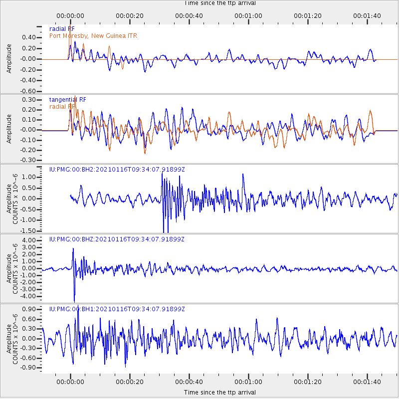
PMG Port Moresby, New Guinea - Earthquake Result Viewer
*The percent match for this event was below the threshold and hence no stack was calculated.
| Earthquake location: |
Southwest Of Sumatra, Indonesia |
| Earthquake latitude/longitude: |
-6.4/103.9 |
| Earthquake time(UTC): |
2021/01/16 (016) 09:26:39 GMT |
| Earthquake Depth: |
10 km |
| Earthquake Magnitude: |
5.2 Mww |
| Earthquake Catalog/Contributor: |
NEIC PDE/us |
|
| Network: |
IU Global Seismograph Network (GSN - IRIS/USGS) |
| Station: |
PMG Port Moresby, New Guinea |
| Lat/Lon: |
9.40 S/147.16 E |
| Elevation: |
90 m |
|
| Distance: |
42.9 deg |
| Az: |
96.879 deg |
| Baz: |
270.67 deg |
| Ray Param: |
$rayparam |
*The percent match for this event was below the threshold and hence was not used in the summary stack. |
|
| Radial Match: |
53.475273 % |
| Radial Bump: |
400 |
| Transverse Match: |
58.148834 % |
| Transverse Bump: |
400 |
| SOD ConfigId: |
23341671 |
| Insert Time: |
2021-01-30 10:30:17.049 +0000 |
| GWidth: |
2.5 |
| Max Bumps: |
400 |
| Tol: |
0.001 |
|
Signal To Noise
| Channel | StoN | STA | LTA |
| IU:PMG:00:BHZ:20210116T09:34:07.91899Z | 8.003142 | 1.335601E-6 | 1.6688456E-7 |
| IU:PMG:00:BH1:20210116T09:34:07.91899Z | 2.0105236 | 4.0503357E-7 | 2.0145677E-7 |
| IU:PMG:00:BH2:20210116T09:34:07.91899Z | 3.4699302 | 6.520085E-7 | 1.8790249E-7 |
| Arrivals |
| Ps | |
| PpPs | |
| PsPs/PpSs | |


