You are here: Home > Network List > CI - Caltech Regional Seismic Network Stations List
> Station SWS Sam W. Stewart, Westmorland, CA, USA > Earthquake Result Viewer
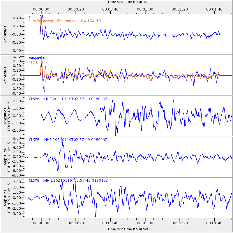
SWS Sam W. Stewart, Westmorland, CA, USA - Earthquake Result Viewer
*The percent match for this event was below the threshold and hence no stack was calculated.
| Earthquake location: |
San Juan Province, Argentina |
| Earthquake latitude/longitude: |
-31.8/-68.8 |
| Earthquake time(UTC): |
2021/01/19 (019) 02:46:22 GMT |
| Earthquake Depth: |
20 km |
| Earthquake Magnitude: |
6.4 mww |
| Earthquake Catalog/Contributor: |
NEIC PDE/us |
|
| Network: |
CI Caltech Regional Seismic Network |
| Station: |
SWS Sam W. Stewart, Westmorland, CA, USA |
| Lat/Lon: |
32.94 N/115.80 W |
| Elevation: |
140 m |
|
| Distance: |
78.2 deg |
| Az: |
321.114 deg |
| Baz: |
140.54 deg |
| Ray Param: |
$rayparam |
*The percent match for this event was below the threshold and hence was not used in the summary stack. |
|
| Radial Match: |
76.39489 % |
| Radial Bump: |
400 |
| Transverse Match: |
81.946846 % |
| Transverse Bump: |
400 |
| SOD ConfigId: |
23341671 |
| Insert Time: |
2021-02-02 03:51:23.777 +0000 |
| GWidth: |
2.5 |
| Max Bumps: |
400 |
| Tol: |
0.001 |
|
Signal To Noise
| Channel | StoN | STA | LTA |
| CI:SWS: :HHZ:20210119T02:57:49.018019Z | 7.334156 | 1.0762751E-6 | 1.4674833E-7 |
| CI:SWS: :HHN:20210119T02:57:49.018019Z | 1.2465276 | 4.2011615E-7 | 3.3702918E-7 |
| CI:SWS: :HHE:20210119T02:57:49.018019Z | 1.3024868 | 6.9604465E-7 | 5.343967E-7 |
| Arrivals |
| Ps | |
| PpPs | |
| PsPs/PpSs | |


