You are here: Home > Network List > G - GEOSCOPE Stations List
> Station TAM Tamanrasset, Algeria > Earthquake Result Viewer
TAM Tamanrasset, Algeria - Earthquake Result Viewer
| Earthquake location: |
San Juan Province, Argentina |
| Earthquake latitude/longitude: |
-31.8/-68.8 |
| Earthquake time(UTC): |
2021/01/19 (019) 02:46:22 GMT |
| Earthquake Depth: |
20 km |
| Earthquake Magnitude: |
6.4 mww |
| Earthquake Catalog/Contributor: |
NEIC PDE/us |
|
| Network: |
G GEOSCOPE |
| Station: |
TAM Tamanrasset, Algeria |
| Lat/Lon: |
22.79 N/5.53 E |
| Elevation: |
1377 m |
|
| Distance: |
89.5 deg |
| Az: |
62.721 deg |
| Baz: |
235.073 deg |
| Ray Param: |
0.041824 |
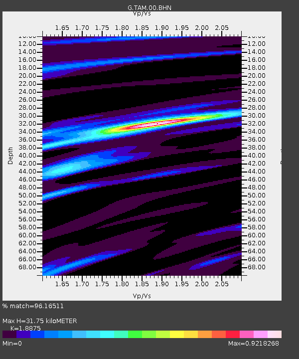
| Estimated Moho Depth: |
31.75 km |
| Estimated Crust Vp/Vs: |
1.89 |
| Assumed Crust Vp: |
6.61 km/s |
| Estimated Crust Vs: |
3.502 km/s |
| Estimated Crust Poisson's Ratio: |
0.30 |
|
| Radial Match: |
96.16511 % |
| Radial Bump: |
372 |
| Transverse Match: |
70.83038 % |
| Transverse Bump: |
400 |
| SOD ConfigId: |
23341671 |
| Insert Time: |
2021-02-02 03:54:25.059 +0000 |
| GWidth: |
2.5 |
| Max Bumps: |
400 |
| Tol: |
0.001 |
|
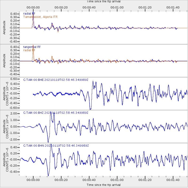
Signal To Noise
| Channel | StoN | STA | LTA |
| G:TAM:00:BHZ:20210119T02:58:46.349989Z | 3.8689485 | 2.4008278E-7 | 6.205375E-8 |
| G:TAM:00:BHN:20210119T02:58:46.349989Z | 1.3520879 | 5.846888E-8 | 4.3243404E-8 |
| G:TAM:00:BHE:20210119T02:58:46.349989Z | 1.628568 | 6.789413E-8 | 4.1689464E-8 |
| Arrivals |
| Ps | 4.4 SECOND |
| PpPs | 14 SECOND |
| PsPs/PpSs | 18 SECOND |


