You are here: Home > Network List > GM - US Geological Survey Networks Stations List
> Station NMP53 New Mexico Permian - Site# W5S3 > Earthquake Result Viewer
NMP53 New Mexico Permian - Site# W5S3 - Earthquake Result Viewer
| Earthquake location: |
San Juan Province, Argentina |
| Earthquake latitude/longitude: |
-31.8/-68.8 |
| Earthquake time(UTC): |
2021/01/19 (019) 02:46:22 GMT |
| Earthquake Depth: |
20 km |
| Earthquake Magnitude: |
6.4 mww |
| Earthquake Catalog/Contributor: |
NEIC PDE/us |
|
| Network: |
GM US Geological Survey Networks |
| Station: |
NMP53 New Mexico Permian - Site# W5S3 |
| Lat/Lon: |
32.18 N/103.43 W |
| Elevation: |
1037 m |
|
| Distance: |
71.6 deg |
| Az: |
329.509 deg |
| Baz: |
149.379 deg |
| Ray Param: |
0.054237258 |
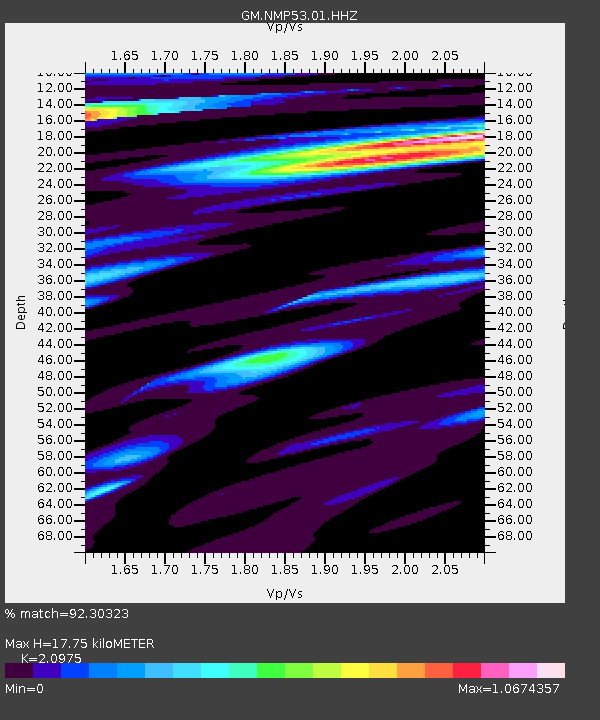
| Estimated Moho Depth: |
17.75 km |
| Estimated Crust Vp/Vs: |
2.10 |
| Assumed Crust Vp: |
6.129 km/s |
| Estimated Crust Vs: |
2.922 km/s |
| Estimated Crust Poisson's Ratio: |
0.35 |
|
| Radial Match: |
92.30323 % |
| Radial Bump: |
400 |
| Transverse Match: |
77.24186 % |
| Transverse Bump: |
400 |
| SOD ConfigId: |
23341671 |
| Insert Time: |
2021-02-02 03:54:51.576 +0000 |
| GWidth: |
2.5 |
| Max Bumps: |
400 |
| Tol: |
0.001 |
|

Signal To Noise
| Channel | StoN | STA | LTA |
| GM:NMP53:01:HHZ:20210119T02:57:10.789992Z | 5.303801 | 1.8501698E-6 | 3.4883848E-7 |
| GM:NMP53:01:HHN:20210119T02:57:10.789992Z | 2.274685 | 5.2779296E-7 | 2.3202904E-7 |
| GM:NMP53:01:HHE:20210119T02:57:10.789992Z | 1.8629493 | 5.731232E-7 | 3.0764295E-7 |
| Arrivals |
| Ps | 3.3 SECOND |
| PpPs | 8.7 SECOND |
| PsPs/PpSs | 12 SECOND |


