You are here: Home > Network List > GS - US Geological Survey Networks Stations List
> Station KS28 W Mills Ave, Hutchinson KS > Earthquake Result Viewer
KS28 W Mills Ave, Hutchinson KS - Earthquake Result Viewer
| Earthquake location: |
San Juan Province, Argentina |
| Earthquake latitude/longitude: |
-31.8/-68.8 |
| Earthquake time(UTC): |
2021/01/19 (019) 02:46:22 GMT |
| Earthquake Depth: |
20 km |
| Earthquake Magnitude: |
6.4 mww |
| Earthquake Catalog/Contributor: |
NEIC PDE/us |
|
| Network: |
GS US Geological Survey Networks |
| Station: |
KS28 W Mills Ave, Hutchinson KS |
| Lat/Lon: |
37.99 N/97.99 W |
| Elevation: |
482 m |
|
| Distance: |
74.6 deg |
| Az: |
336.475 deg |
| Baz: |
154.527 deg |
| Ray Param: |
0.052224044 |
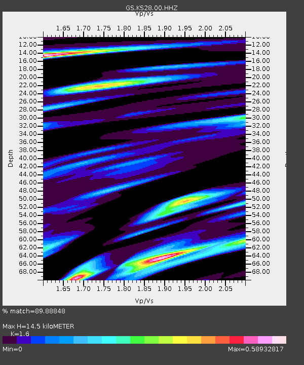
| Estimated Moho Depth: |
14.5 km |
| Estimated Crust Vp/Vs: |
1.60 |
| Assumed Crust Vp: |
6.483 km/s |
| Estimated Crust Vs: |
4.052 km/s |
| Estimated Crust Poisson's Ratio: |
0.18 |
|
| Radial Match: |
89.88848 % |
| Radial Bump: |
400 |
| Transverse Match: |
79.62889 % |
| Transverse Bump: |
400 |
| SOD ConfigId: |
23341671 |
| Insert Time: |
2021-02-02 03:55:12.445 +0000 |
| GWidth: |
2.5 |
| Max Bumps: |
400 |
| Tol: |
0.001 |
|

Signal To Noise
| Channel | StoN | STA | LTA |
| GS:KS28:00:HHZ:20210119T02:57:28.623976Z | 7.163823 | 1.3245923E-6 | 1.8490019E-7 |
| GS:KS28:00:HH1:20210119T02:57:28.623976Z | 4.1328106 | 6.1928733E-7 | 1.4984653E-7 |
| GS:KS28:00:HH2:20210119T02:57:28.623976Z | 2.1262066 | 4.9917975E-7 | 2.347748E-7 |
| Arrivals |
| Ps | 1.4 SECOND |
| PpPs | 5.6 SECOND |
| PsPs/PpSs | 7.0 SECOND |


