You are here: Home > Network List > NM - Cooperative New Madrid Seismic Network Stations List
> Station MPH Memphis, TN > Earthquake Result Viewer
MPH Memphis, TN - Earthquake Result Viewer
| Earthquake location: |
San Juan Province, Argentina |
| Earthquake latitude/longitude: |
-31.8/-68.8 |
| Earthquake time(UTC): |
2021/01/19 (019) 02:46:22 GMT |
| Earthquake Depth: |
20 km |
| Earthquake Magnitude: |
6.4 mww |
| Earthquake Catalog/Contributor: |
NEIC PDE/us |
|
| Network: |
NM Cooperative New Madrid Seismic Network |
| Station: |
MPH Memphis, TN |
| Lat/Lon: |
35.12 N/89.93 W |
| Elevation: |
93 m |
|
| Distance: |
69.5 deg |
| Az: |
341.646 deg |
| Baz: |
160.912 deg |
| Ray Param: |
0.05560358 |
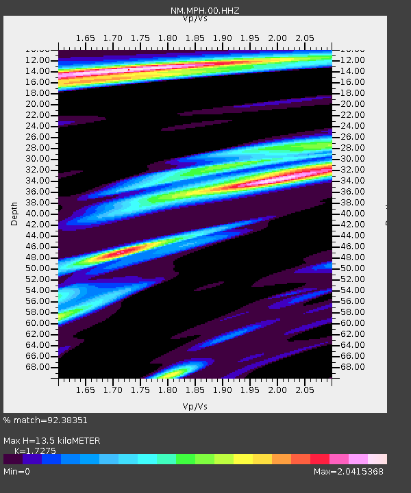
| Estimated Moho Depth: |
13.5 km |
| Estimated Crust Vp/Vs: |
1.73 |
| Assumed Crust Vp: |
6.38 km/s |
| Estimated Crust Vs: |
3.693 km/s |
| Estimated Crust Poisson's Ratio: |
0.25 |
|
| Radial Match: |
92.38351 % |
| Radial Bump: |
261 |
| Transverse Match: |
80.87383 % |
| Transverse Bump: |
400 |
| SOD ConfigId: |
23341671 |
| Insert Time: |
2021-02-02 04:00:33.086 +0000 |
| GWidth: |
2.5 |
| Max Bumps: |
400 |
| Tol: |
0.001 |
|

Signal To Noise
| Channel | StoN | STA | LTA |
| NM:MPH:00:HHZ:20210119T02:56:58.099989Z | 9.964767 | 4.3962846E-6 | 4.4118283E-7 |
| NM:MPH:00:HHN:20210119T02:56:58.099989Z | 2.8542826 | 2.0954544E-6 | 7.3414395E-7 |
| NM:MPH:00:HHE:20210119T02:56:58.099989Z | 1.0771852 | 8.444907E-7 | 7.8397915E-7 |
| Arrivals |
| Ps | 1.6 SECOND |
| PpPs | 5.6 SECOND |
| PsPs/PpSs | 7.2 SECOND |


