You are here: Home > Network List > NN - Western Great Basin/Eastern Sierra Nevada Stations List
> Station MCM07 Monte Cristo Menlo 07 > Earthquake Result Viewer
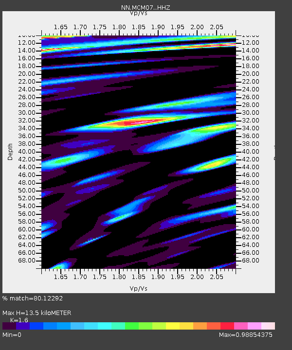
MCM07 Monte Cristo Menlo 07 - Earthquake Result Viewer
| Earthquake location: |
San Juan Province, Argentina |
| Earthquake latitude/longitude: |
-31.8/-68.8 |
| Earthquake time(UTC): |
2021/01/19 (019) 02:46:22 GMT |
| Earthquake Depth: |
20 km |
| Earthquake Magnitude: |
6.4 mww |
| Earthquake Catalog/Contributor: |
NEIC PDE/us |
|
| Network: |
NN Western Great Basin/Eastern Sierra Nevada |
| Station: |
MCM07 Monte Cristo Menlo 07 |
| Lat/Lon: |
38.23 N/117.75 W |
| Elevation: |
1716 m |
|
| Distance: |
83.3 deg |
| Az: |
323.301 deg |
| Baz: |
139.761 deg |
| Ray Param: |
0.046303026 |
| Estimated Moho Depth: |
13.5 km |
| Estimated Crust Vp/Vs: |
1.60 |
| Assumed Crust Vp: |
6.276 km/s |
| Estimated Crust Vs: |
3.922 km/s |
| Estimated Crust Poisson's Ratio: |
0.18 |
|
| Radial Match: |
80.12292 % |
| Radial Bump: |
400 |
| Transverse Match: |
74.30673 % |
| Transverse Bump: |
400 |
| SOD ConfigId: |
23341671 |
| Insert Time: |
2021-02-02 04:01:28.632 +0000 |
| GWidth: |
2.5 |
| Max Bumps: |
400 |
| Tol: |
0.001 |
|

Signal To Noise
| Channel | StoN | STA | LTA |
| NN:MCM07: :HHZ:20210119T02:58:16.005019Z | 3.7414627 | 1.5203086E-6 | 4.0634072E-7 |
| NN:MCM07: :HHN:20210119T02:58:16.005019Z | 0.96309566 | 4.1034696E-7 | 4.2607084E-7 |
| NN:MCM07: :HHE:20210119T02:58:16.005019Z | 3.1223602 | 4.826668E-7 | 1.5458396E-7 |
| Arrivals |
| Ps | 1.3 SECOND |
| PpPs | 5.4 SECOND |
| PsPs/PpSs | 6.8 SECOND |


